Tom Dooley - An update 2
In this, my second update I will look a little closer at the area of the murder and especially where everybody lived. In my first articles I haven't used much time and space on that, as it didn't matter much, except maybe for the time Tom and Laura would have used getting from Lauras home to the Bates place, and I have alrady explained in a couple of articles, that I find the timetable from the trials improbable. The problem is, that our only real description of how the area looked at the time of the murder, is the map drawn by James Isbell. He testified at the trials, "that the map was a faithful representation of the various locations designated, that he was well acquainted with the neighborhood, and had made the map himself, that various places and the distances put down was correct, that Wilson Foster, the father of the deceased, lived in Caldwell County, that the prisoner, Dula, and James Melton, husband of Ann lived in Wilkes County, that Elk Creek was the dividing line bewtween the two counties in this vicinity".
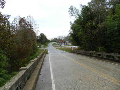
The photo on the left, is taken on the bridge leading NC 268 across Elk Creek about half a mile north of where the river joins the Yadkin. The road leading left on the other side of the bridge is present day Elk Creek Darby Road and opposite is Eller's Store.
Fortunately he was right about some of the things, that he testifed on, but definately not all. Elk Creek was the dividing line between Wilkes and Caldwell counties at that time, Tom and James Melton did live in Wilkes County and Wilson Foster did live in Caldwell County. But as to the locations and distances, the map is definitely not very precise. The same goes for other aspects, like the direction of the Yadkin River and Elk Creek, and different scales is used in different parts of the map, making it very hard to "read". One example is the distance between what on the map is called Linville Branch and Elk Creek and the distance between Elk Creek and Reedy Branch. On the map the two distances look almost the same, but in reality, there is a little over two miles from the mouth of Linville Branch (present day: Laytown Creek) to the mouth of Elk Creek, whereas there are only one mile from Elk Creek to Reedy Branch. This means that the western part of the map is drawn at a smaller scale that the eastern part of the map.
The Yadkin River is drawn as an almost straight line running in a southeasterly direction, and Elk Creek is another straight line running almost north northeast to north and none of this is correct, as everybody can convince themselves about, just by looking at a map of the area. The Elk Creek is running in a north northeasterly direction and taking quite a few bends along the way, and The Yadkin is actually running more northeast then southeast, and it is actually meandering a lot in this particular area. If you look at Isbell's map it looks as if Rufus D. Horton lived a little southeast of David E. Horton, but actually he lived straight east of him, and you could keep going on like that. Also the map shows only a few houses along the river, where actually many more existed at the time.
I don't think that Isbell lied in his testimony, I just think he didn't know the area as well as he thought himself, or didn't draw very well, and nobody bothered to look into the matter at the time of the trial. I don't think either, that the missing precision of the map had any saying in the outcome of the trial, but anyway in this update I will look further into the layout of the land at the time of the murder of Laura Foster.
I base this update mainly on the book, (rather a collection of newspaper columns) The World of My Childhood by Reverend Dr. Robert Lee Isbell. Robert Isbell was born in 1871 as the son of Tom Dooley's nemesis, James Isbell, and his wife, Sarah Louise Horton and he died in Lenoir in 1954. He wasn't yet born at the time of the murder, and his book is mainly about the period from 1875 to 1885, but he also tells a little about the time before his own birth, and has two articles on the murder. I will probably get back to those in a future update, but here I will focus on the layout of the area.
One challenge is, that Mr. Isbell's geographical scope is rather narrow. "The world of his childhood" is a rather narrow strip of land along the Yadkin River and only five or six miles in length, stretching from German's Hill in the west to Elkville in the east, and he doesn't tell much about people living outside this limited area. A few is mentioned though. Other souces are the two books by John Foster West and a new book by John Fletcher, The True Story of Tom Dooley. I have also used a registration form, nominating the Dula-Horton Cemetery for the National Register of Historic Places. This form contains some interesting historical and geographical facts.
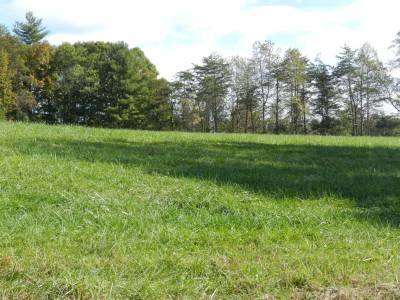
The picture on the left shows a small grassy hill in Elkville, where Cowles' store once stood. This is on the opposite side of NC 268 from present day Eller's Store.
To make it more difficult to place the different involved or mentioned people, even the wealthy land owners did not always live on the land they owned, and did not necessarily own the land, they lived on. An example is Phineas Horton, who owned a large tract of land in the valley, worth $ 5.200 i 1870, but lived in the home of his brother Rufus D. Horton as he did in 1866. Another example is Calvin Cowles who owned the store in Elkville from 1846 til 1858 at which time he moved to Wilkesboro. He may have owned the store in 1866, even it it was run by someone else, we don't know, but we do know, that he owned a tract of land on the south side of the river, west of Elkville as late as in the 1870's. This farm was run by a tenant farmer, Joseph Jones. This particular tract of land had once belonged to William Beasley Dula, Tom Dulas first cousin, once removed. William got in a debt to Calvin Cowles of several thousand dollars (an very large amount of money in those days), and Cowles accepted the tract of land as payment. (R. L. Isbell, The World of My Childhood, p. 136).
Another thing, that makes correct placement difficult, is that Reverend Isbell identifies many locations, by refering to people who lived there at the time of his articles. Let me quote just one passage: "I begin my writeup of The World of My Childhood on the south side of the Yadkin River, and in the upper end of what is now Johnny Fraziers handsome farm, where Mr. Joseph Jones was a tenant on land that then belonged to Calvin Cowles..." (The World of My Childhood, p. 136). If you lived in the area around 1950, you may very well have known, where Johnny Fraziers farm was situated, and even today some locals may know the place, but being an outsider it is very difficult to localize the exact spot. Luckily Mr. Isbell writes about the inhabitants of the area in many of his articles, making it possible to piece together some locations. By the way, John Foster West used the same teqnique by referring to people that were known at the time of the book, when he localizes people fromn the past.
Originally (around 1795) there were three big landowners in Happy Valley between Patterson and Elkville. From west to east, they were Edmund Jones, William Lenoir and William Dula. It's worth to notice, that their lands were scattered over most of the valley. For instance William Dula owned land both west of Edmund Jones near Patterson, close to the home of William Lenoir in present day Yadkin, and close to his own home in Elkville, and the same was the case with the other two large landowners. Later their plantations were split up between children, some were sold or given away, so at the time of the murder, there were about 200 people or more living in the area, but only representing a few families, and most were related to each other. Still the big landowners lived in the valley, and still their real estate was scattered over large parts of the valley and mountains.
Getting started
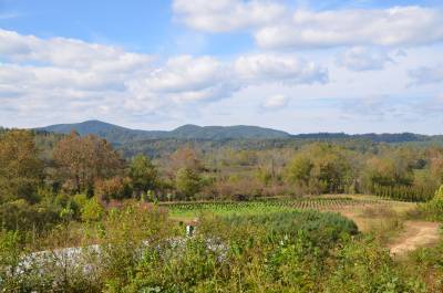
The picture on the left shows Yadkin River Valley seen from NC 1164 (Tom Dula Road) in Caldwell County.
Fortunately there are a few fixed points, that are rather easy to locate, just using a map and/or Google Earth. The Yadkin River runs through the whole valley, and everyone from the case, lived in the neighborhood of this river. In James Isbell's map, three tributaries are shown, all reaching The Yadkin from the north. Some of the involved lived along these tributaries, so identifying those is almost a prerequsite of locating the rest. All of these tributaries along with others, still exist and meet Yadkin River, where they did in 1866. Furthest to the east, is Reedy Branch where Tom Dooley himself lived. This small creek crosses NC 268 around 50 yards west of present day Bill Horton Road and it enters Yadkin around 240 yards south of NC 268. This creek is outside the scope of Reverend Isbell, so the only information about who lived here, from his articles is found in the two articles containing the story of the murder.
Next on Isbells map is Elk Creek. This rather large river, even larger than the Yadkin at this spot, crosses NC Route 268 80 yards west of Elk Creek Derby Road and enters The Yadkin after having meandered south for around 1,000 yards (or 700 yards south of NC 268 as the crow flies). The witnes Hezekiah Kendall lived on the Elk Creek, but someway north. In the neighborhood of the mouth of Elk Creek lived the witnesses Rufus D. Horton and J. W. Winkler. Also the Witherspoon familiy lived near Elk Creek, and it was close by, that Cowles' store was situated. Hopefully in a future update I will be able to place everybody on a modern day map.
Next on Isbells map is a small stream, that he calls Linville Branch, that can't be found in modern maps. R. L. Isbell identifies it as Linville Mill Creek, and that name has disappeared as well. Today the stream is known as Laytown Creek, and it runs next to Laytown Road, which runs in a semi-circle and meets NC 268 twice about 2.4 miles apart. Laytown Creek is near the easternmost end of the road. Near the mouth of the river, was the home of witness Calvin Catlett Jones, who lived in a house, originally build and owned by William B. Dula, a first cousin of Tom's father, who passed away in 1856. Across present day NC 268 from C. C. Jones was the tract owned by Calvin Cowles and run by tenant farmer Joseph Jones. Further north along the creek was the homes of witnesses Cal(vin) Carlton and Taylor Land* and also Toms second cousin, James E. Dula, son of William B. James E. wasn't involved in the case and did not appear as witnes at the trials.
* In the first article in which I mentioned Taylor Land, I could only find a woman by that name in the official records, but the Taylor Land in question was actually male, I just couldn't find him then, but have later on. He lived not far from Calvin Carlton near Laytown Creek.
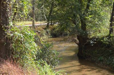
The picture on the left shows Kings Creek. In the background you can spot Tom Dula Road. We are south of the Yadkin. Tom Dula Road was once part of the main road between Wilkesboro and Lenoir.
Another Yadkin Tributary is easily identified, King's Creek. It runs into The Yadkin from the south, and as Isbell's map shows absolutely nothing, south of Yadkin River, King's Creek isn't shown either. It crosses Grandin Road around 250 yards north of Tom Dula Road (NC State Road 1164) and parallels this for about a mile east before entering Yadkin River. Near the mouth of King's Creek was the home of Lafayette Greer, who was the husband of James Isbell's daughter, Cornelia.
Four more known places are available. The first one is the Dula-Horton Cemetery, first established by Captain William Dula, and used by several of his descendants from the Dula, Jones and Horton branches of the family. The cemetery is situated 300 yards south of his old home. After Williams death, this house was used by James Isbell's father in law, David E. Horton, and his wife, Sarah, who was a daughter of Captain William. David Hortons old home was taken over by his brother James C. Horton. The Dula-Horton cemetery is situated a quarter of a mile south of NC 268 at the end of Council Farm Drive. At the time of the murder, David E. Horton lived about 300 yards north of the cemetery in his father-in-laws old home. This house burned down in 1949 and today a modern home is found on the site.
The remaining three known places are also cemeteries. First we have the Isbell Cemetery, now a part of Grandin Baptist Church Cemetery, but then on Isbell land. This cemetery is found around 150 yards up Howell Farm Road from Grandin Road. If how other familiy cemeteries were placed are taken into account, the Isbell farm house must have been no more than 200 or 300 yards from the cemetery. For some reason Rev. Isbell never told where his own childhood home was located - maybe everybody knew at the time of the articles. The book has a picture of his home, but not a description of where is was situated. As most larger farmhouses were placed on hilltops, I figure that the Isbell home was some 250 yards east of the present day church but I can very well be wrong. Another cemetery is the Dula cemetery, where Tom's grave is found today, as the only grave with a stone on it. This is next to Tom Dula Road (NC State Road 1164) around 1.2 mile southwest of where this road leaves NC 268 at the crossing of Yadkin River. Tom's grandfather, Bennet Dula had his home on the hill behind the grave. At the time of the murder it was owned by Tom's uncle, Bennett J. Dula (the father of Ann Dula and Granville Dula from the arrest warrant). And finally the Melton Cemetery. It's a bit away from the river, on a ridge around 1.5 miles north of the river. The cemetery is about half way up a small road leading from Gladys Fork Road to the top of the ridge. The small road is around 200 yards west of where Bill Horton Road meets Gladys Fork Road.
More locations
From these fixed points, I have tried to locate the homes of other people involved in the case, or witnesses at the trial. Some can be placed with a good deal of certainty, while others could very well be placed wrong.
About half a mile west of C. C. Jones, William Holder, who took part in the Friday night party at the Melton place, lived. He was a tenant farmer of a widow, Mrs. John Jones. William Holder and Joseph Jones were brothers in law according to Rev. Isbell. Mrs. John Jones owned the land, but apparently didn't live on the land herself. South of Mrs. Jones' farm a invalid woman named Moriah Ernest (a grandaughter of Captain William Dula according to Robert Isbell) owned a large farm, stretching from the river to the German Mountains. About a mile east of Moriah Ernest, was the rather large farm of Dr. George N. Carter, near the end of present day Croppage Farm Road, a small road leading north from Grandin Road around 100 yards south east of Zacks Ford Road. James Meltons brother, Francis Melton was a tenant farmer on Dr. Cartes land for more then 40 years, even if apparently he didn't live close to the farm of Dr. Carter at the time of the murder. As some farm lands were spread out, Dr. Carter might have owned the land, where both Francis and James Melton lived as well as his farm near the river. In 1870 Francis Melton and his family had moved to Buffalo in Caldwell County, still working as Dr. Carter's tenant farmer. James Isbell's father, Thomas Isbell, had his farm alongside that of Dr. Carter. The farm was sold to a James Steele, and at the time of the murder his son, John Steele lived at the place.
Unfortunately Rev. Isbells world stops at Elkville. James C. Horton and Bennett Dula are is the only two persons, he mentions that lived closer to Ferguson and they both lived south of the Yadkin, so it tells us nothing of where the rest of the involved lived. Here we have to turn to more moderne writers like John Foster West and others.
The directly involved
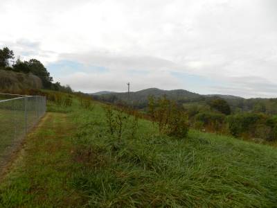
The picture on the left is taken right outside the Melton Family Cemetery (behind the fence to the left of the photo) looking in the direction of James and Ann's old home, further up the ridge.
One of the places that still can be identified today as mentioned above, was the Melton Familiy Cemetery, which is located 100 yards from Gladys Fork Road beside a small, unnamed road leading up to a ridge. John Foster West and others agree that the home of Lotty Fosters was a short distance up the ridge from the cemetery. This means, that Lotty Foster lived where today modern buildings are situated on this ridge. According to the comments on James Isbell's map from the trial, Mrs. Mary Dula's cabin was half a mile below Lotty Foster on the opposite bank of Reedy Branch. This indicates, that using the Bill Horton Road of today, you should drive or walk 0.4 miles down this road and the Dula place should have been where there is now a small meadow, reaching from the road down to the branch. Unfortunately this is not the place, where Tom's home was, according to local tradition. This place, where Tom Dooley lived according to the "Tom Dooley Historical Tour", a modern day drive around the area, is almost another half a mile down Bill Horton Road and one mile from Lotty Fosters, as the crow flies. So who is right here, Isbell's map or tradition? Once more I believe in tradition, rather than in Isbells map, as this places Toms home in a moist meadow, whereas tradtion place it on top of a small hill, which was usual at the time.
This problem also makes it difficult to locate the site of Laura's grave. According to Isbell the grave was found between one half and three quarters of a mile from the supposed murder site and 400 to 500 yards from Dula's home. If the Dula home was where tradition locates it, it's simply not possible for the grave to be within 500 yards of the Dula cabin as well as within 0.75 miles of the place of the murder, whereas it works, if the Dula home actually, was where Melton placed it on his map. During my last visit to the area, I was told that the remains of the Dula cabin was still where it used to be as late as in the early 1900 years, which speaks in favor of tradition, as there must have been people alive, who rembered it, when the historical tour was first made. So maybe, just maybe, James Isbell understated the distance between the Dula home and the grave in order to further stress the likelyhood of Tom digging the grave.
Anyway, James and Ann Melton lived further up the ridge from Lotty Foster, and not far from them to the east lived James' brother Francis and his familiy. The two brothers lived more than 350 yards apart. We know from Robert Isbells book, that Francis Melton was a tenant farmer on land bnelongign Dr. G. Carter, and with the short distance between them, it's reasonable to believe that so was James**. From census records we know that neither of them owned the land, that they lived on. Unfortunately we can't assume, that the other people in the neighborhood, the Scotts, the Andersons and the Griffins also lived on Carter lands, as the land was divided by different owners as mentioned above. Actually it is not certain to assume that Dr. Carter owned the tract of land where Meltons lived. It could have been owned by someone else, and Francis can have been working Carter land closer to the Yadkin.
The Scott's lived next to James and Ann but to the west and also on somebody else's land, and Carson Dula lived north west of the Scotts on a road that was then called Elk Road. This road doesn't exist today.
** Unfortunately Dr. Isbell doesn't distinguish between tenant farmers and sharecroppers, but call all tenants for tenant farmers. I believe it is more likely that the Melton brothers were sharecroppers, that tenant farmers.