Arches, canyons and slickrock
When checked into the hotel in Moab after the visit at Mesa Verde National Park, it was around 3.30 PM and we agreed that we had time for a short visit to the Arches National Park, located just north of Moab. The national park has the largest concentration of natural arches anywhere in the world. The entire area, not just the arches, is one of the most impressive and exciting places I've ever seen. It is on my personal Top Ten List of natural wonders, together with Painted Desert in Arizona, Grand Canyon NP, Yellowstone NP and Redwood NP in the US of A. Number one, by the way is Jakobshavn Isbræ or Jakobshavn Glacier in Greenland.
 The
park has a lot of viewpoints where you can park the car and look at the nature,
and from many of these viewpoints, you can also go on short or longer walks. We
stopped at a few of them, but going into the park, we only stopped at
viewpoints at the main road. Among the stops we made were at Balanced Rock and
Petrified Dunes.
We saved the side roads and their stops for the return trip.
The
park has a lot of viewpoints where you can park the car and look at the nature,
and from many of these viewpoints, you can also go on short or longer walks. We
stopped at a few of them, but going into the park, we only stopped at
viewpoints at the main road. Among the stops we made were at Balanced Rock and
Petrified Dunes.
We saved the side roads and their stops for the return trip.
We continued until
the park road ended at Devils Garden. Here we parked the car and went for a
walk of about 1.5 miles into the valley behind the car park to see the park's
widest arch, Landscape Arch, which is nearly 300 feet from side to side. On the
way back we looked at a few more arches. Even at this time in the afternoon the
temperature was still around 95 degrees, so along the way we emptied our
water bottles. We got back to the parking lot though, without dying from thirst,
and then we started on our return trip.
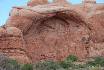
The next stop was at one of the side roads. Here we looked at the Delicate Arch,
the park's biggest icon, which is pictured on license plates from Utah. Here you
have three choices. You can take a stroll up to the arch which stands on a ridge,
a trip of around 45 minutes each way. It was too late in the afternoon to take
this route, and we had not enough
water left in our cooler. Another possibility is that which Dorte and I took in
2006, namely to go to the "upper viewing point." It is a walk of about one
kilometer, which rises about 250 feet. Since Tim and I was already tired after
our walks in Mesa Verde and at Landscape Arch, we chose the third option, namely
to look at the arc from "lower viewing point." Here you don't have to climb at
all, its just about a 300 feet walk from the parking lot.
From Delicate Arch, we drove to our last stop on the tour at the Windows Section.
The Windows are two large arches, North Window and South Window and we walked up
to see those. I also walked halfway to Double Arch, which as the name suggests, is
an arch with two openings. By then we had seen enough of arches, so we left
the park with only a few more stops to take pictures.
When we were back in town was almost 19 o'clock, so we decided to find somewhere
to eat. We had at one point seen a sign that advertised a restaurant with the
interesting name Branding Iron, so we looked that up. It turned out to be a nice,
but almost empty restaurant. The food, however, was really good, and here there
was plenty of it and it was not particularly expensive. Then we went back to the
hotel so we could get rested after a long day's enjoyment of the landscapes
of southeastern Utah.
A visit to Canyonland National Park
 The
next day, we were going to visit the southern part of Canyonlands National Park,
and as we had to change our hotel, we packed our stuff and paid our bill before
leaving. Back home we had checked the internet, and decided to take a sunset
off-road tour in a hummer. The day before we had passed several tour providers, but
as we did'nt know anything about any of them, we simply stopped at the first one
we passed and booked the tour for the same evening. It cost us the tidy sum of $
80 each but as it later turned out, is was worth every penny of it. Before we
could get the ticket we had to sign a statement saying the tour was on our own
risk, and if we were injured on the trip, we could not sue
the company.
The
next day, we were going to visit the southern part of Canyonlands National Park,
and as we had to change our hotel, we packed our stuff and paid our bill before
leaving. Back home we had checked the internet, and decided to take a sunset
off-road tour in a hummer. The day before we had passed several tour providers, but
as we did'nt know anything about any of them, we simply stopped at the first one
we passed and booked the tour for the same evening. It cost us the tidy sum of $
80 each but as it later turned out, is was worth every penny of it. Before we
could get the ticket we had to sign a statement saying the tour was on our own
risk, and if we were injured on the trip, we could not sue
the company.
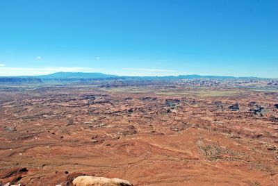
With the evening tour booked, we drove south along the same road but in the
opposite direction of where we came from the day before. About 30 miles south of
Moab, we left the highway to drive to the so-called Needles Overlook. 20 miles
from the main road we came to a viewpoint from where we could look out over the
area of Canyonlands National Park, that is known as The Needles because of its
many sharp and pointed rocks. From the viewpoint we also had a good view of the
Colorado River, which here floated through a canyon that was not quite as deep
as the Grand Canyon, but impressive just the same. We went for a walk in the
area and enjoyed the countryside and also tried to walk on the slickrock cliffs,
which are some very smooth, though not slick sandstone cliffs
Canyonlands is a relatively small national park (around 525 square miles), but
as it is traversed by both the Colorado River and the Green River, it is divided
into three separate and independent areas, and you can't drive between them
inside the park, but have to leave the park for that purpose. The northernmost
part is called "Island in the Sky" and the entrance to this part is situated
about 25 miles north of Moab. The southernmost region is the "Needles Area",
located about 40 miles south of Moab. The last area is "The Maze", located west of
both Green River and Colorado River. This area is the park's most inaccessible
area, and one of the most inaccessible areas throughout the U.S. and it is only
possible to visit the area in 4-wheel drive vehicles with high clearance, on foot
or on horse or mule back. When had completed our visit to the overlook, we
agreed that we would go on south and visit the Needles area, which was what was
closest. The Maze sounded exciting, but our Camaro was not exactly a
high-clearance 4-wheel drive vehicle, and we didn't have between 3 days and one
week to spend, as a park brochure recommended.
We therefore drove the 20 miles back to the highway (U.S. Route 191) and
another 10 miles or so further south. Here again we left the main road and
continued the approx. 30 miles to the area's Visitor Center. The road to the
park was very interesting and varied, from rocks and desert, to prairie with
cattle and along rivers and other waterways, there was a lot of green vegetation
with many poplars and dogwoods. Along the way we saw a sign to Newspaper Rock,
but we decided to wait to explore this place until our return trip. We proceeded
to the entrance to the park where we once again showed our annual pass, and then
we entered the park and drove to the local Visitor Centre, where we bought water,
because the cooler was empty, and also looked at the exhibition on the park.
 Then
we followed the "main road" around the Needles district, but only where 2-wheel
drive was permitted, and we stopped several places to "walk" and take pictures.
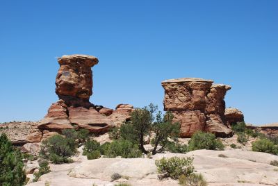
The first place we stopped was at a viewpoint from which you could see the
Wooden Shoe Arch. This is a pretty little arch, and the hole and the formation
of the rock gives the impression of a giant clog.
Then
we followed the "main road" around the Needles district, but only where 2-wheel
drive was permitted, and we stopped several places to "walk" and take pictures.
The first place we stopped was at a viewpoint from which you could see the
Wooden Shoe Arch. This is a pretty little arch, and the hole and the formation
of the rock gives the impression of a giant clog.
Next stop was at Potholes Point. Here we here we took a walk for about one mile to look at the many "potholes". They are small depressions in the sandstone cliff where water is collected during rainfalls. During wet periods these potholes are filled with life, but when we were there, they were completely dried up and we saw only a few scattered trees and some cacti.
Last stop was at Slick Rock
viewpoint where we took a walk of about 2.5 miles on the smooth rocks. From here
we could enjoy the view of Big Spring Canyon together with a French family who
were the only other people we saw in the area, but for one cyclist, who we had
overtaken somewhat earlier in the day. On the way back we followed a very small,
and as it turned out very winding dirt road. This we followed for about 6 miles, and we
repeatedly had to be edging us past the oncoming traffic (two cars). At the end
of the road was a ravine, where we took a few pictures and then we drove back.
On the way back we stopped briefly at some small Ancestral Pueblo ruins, and we
left the park for this time.
On the way back from the park to the highway, we stopped at Newspaper Rock,
formerly a state park, but now classified as a State Historical Monument. Here
is a hillside covered in "rock paintings", petroglyphs. Actually they are not
painted but made by scratching the dark surface, so the lighter rock
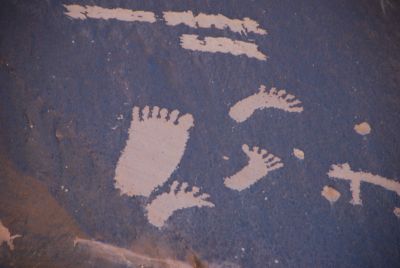 underneath
are becoming visible. According to a sign they were made sometime between the
year 1 and year 1300 AD. It surprised us somewhat, since among others there were
drawings of horses, and these did not live in North America at this time. After
we got home, I have read that some of the images are made in the so-called
Navajo-time, ie the period after the Navajos came to the area. This happened
around 1400 and the Spaniards brought horses to North America around 1540, so
these drawings must be more recent than that. In addition to the horses, a
quantity of images showed animals, from deer and bison to something that most of
all reminded me of beetles. As with carvings in Bornholm, Denmark and Simrishamn,
Sweden there are also plenty of sun symbols and then a large amount of feet,
besides drawings that must depict mythical creatures with human bodies, long
tails and very small heads. It is interesting by the way, that many of the
depicted feet have 6 toes. Had it been a single one, you might think that it
could be a drawing error, but as many as there is, it must be assumed to be
deliberate. So maybe some of the people doing the "drawings" had 6 toes, or
there a reason behind that we do not understand today. For good measure, I
better add that there also were feet with both five and four toes. After
scraping the surface of the drawings again begin to darken when exposed to the
weather and the color can then be used to decide if not the actual age of each
drawing, then at least which of the drawings are the oldest. Here it is
noteworthy that the 6-toed feet are among both the oldest and the younger
drawings.
underneath
are becoming visible. According to a sign they were made sometime between the
year 1 and year 1300 AD. It surprised us somewhat, since among others there were
drawings of horses, and these did not live in North America at this time. After
we got home, I have read that some of the images are made in the so-called
Navajo-time, ie the period after the Navajos came to the area. This happened
around 1400 and the Spaniards brought horses to North America around 1540, so
these drawings must be more recent than that. In addition to the horses, a
quantity of images showed animals, from deer and bison to something that most of
all reminded me of beetles. As with carvings in Bornholm, Denmark and Simrishamn,
Sweden there are also plenty of sun symbols and then a large amount of feet,
besides drawings that must depict mythical creatures with human bodies, long
tails and very small heads. It is interesting by the way, that many of the
depicted feet have 6 toes. Had it been a single one, you might think that it
could be a drawing error, but as many as there is, it must be assumed to be
deliberate. So maybe some of the people doing the "drawings" had 6 toes, or
there a reason behind that we do not understand today. For good measure, I
better add that there also were feet with both five and four toes. After
scraping the surface of the drawings again begin to darken when exposed to the
weather and the color can then be used to decide if not the actual age of each
drawing, then at least which of the drawings are the oldest. Here it is
noteworthy that the 6-toed feet are among both the oldest and the younger
drawings.
When we had finished "reading the news", we returned to the highway road and
drove back toward Moab. Along the way, we made one stop to switch drivers. We
did this at "Hole'n the Rock". This is a house or an apartment, carved directly
out of the rock. The property has approximately 4,000 square feet (14 rooms), and is
carved out of the sandstone cliffs by the Dane Albert Christensen, and was
inhabited by him and his wife Gladys until his death in 1957. She lived in and
developed the house further until her death in 1974. They are both buried in a
niche in the mountain in the garden outside their home. On the rock wall is a
carved portrait of Franklin D. Roosevelt made by Albert Christensen.
When we got back to town, we continued further north and around 12 miles to the
east along Utah Route 128 next to the Colorado River to our "new" hotel. Why we only
stayed here one night and not both nights is a long story, but it all meassured
up to my bad memory of when we were goint to get to Moab. At the front desk
we explained the very cute young lady, that we had made a booking error, and
thus only had to use the room for one day, as we had to be in in Salt Lake City
the day after. She changed our reservation to 1 instead of 2, nights and then we
got our room key after she had told us about the hotel's own Wild West movie
museum, their winery, restaurant, etc. The room was as we expected, with king
size bed. We knew because it was the only available room, when we booked from
back home, so we were prepared for it. On the other hand, it was a suite with
1½ floors with a kitchen and living room section down a few steps from the
hall and sleeping area. Outside the living room area, there was access to a
private terrace overlooking the Colorado River and the impressive red cliffs on
the other side. If you get to Moab and don't mind the 200 something dollars per
night, you simply have to stay at Red Cliff's Lodge. While Tim visited the Wild
West Museum, I visited the winery, and bought a few bottles.
Off-road on the slickrock
Around 5.45 PM we drove back to
Moab, where we were ffifteen minutes later but our mempories had failed us,
and the Hummer-tour didn't start until 7 PM. While we waited, we sat on a
terrace each in a rocking chair and enjoyed the surroundings. As the time for
leaving approached, we were greeted by Nick, who should be our driver. We were also presented to the other participants in
the trip, a family of three from Massachusetts: a father, a mother, and their
son, Kyle at around 15 or 16. So we took off on what should be the greatest
experience of our whole vacation and easily worth the price.
 Moab
is called "the off-road capital of the world" because of the many possibilities
for trips by car or better, jeep, or small ATV's or moutainbike on the slickrock
cliffs around the town. Slickrock is sandstone, actually petrified dunes, which
gradually have been eroded completely smooth, and as it is the dunes, which are
fossilized, they are also rounded but can also be quite steep. Slick Rock is
called Entrada Sandstone in geological terms, if anyone would like to look it
up somewhere
Moab
is called "the off-road capital of the world" because of the many possibilities
for trips by car or better, jeep, or small ATV's or moutainbike on the slickrock
cliffs around the town. Slickrock is sandstone, actually petrified dunes, which
gradually have been eroded completely smooth, and as it is the dunes, which are
fossilized, they are also rounded but can also be quite steep. Slick Rock is
called Entrada Sandstone in geological terms, if anyone would like to look it
up somewhere
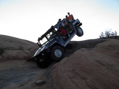
We drove to the outskirts of town where the rock begins and along the way Nick
told us about off-roading. Here they evaluate the rides on a scale from 1
to 10 according to how hard they are to drive. The tour, we were going to drive
was called Hell's Revenge and was a 6. It's hard to describe the drive. One can
not really describe how high and steep the hills, we drove up and down, really
were. But they were! The vehicle we rode in was a Hummer H1, the first and
greatest of Hummers. It is directly based on the military Humvee and can stand a
little of everything. 70-degree increments with lateral tilt of up to 47
degrees will be all right. Mother Judy suffered from vertigo, so she spent most
of the time with her eyes closed, to great amusement, not least to her son. The
first challenge came just after the ride had started. Here drove along
Chicken Fin, a narrow cliff about 60 feet high, that was no wider than the
Hummer. Here one could look out of the car and straight into a gap, regardless
of which side you were placed. We also tried to go backwards up along a 120 feet
high hill. We had at one point one rear wheel at least three feet above the
ground. On another occasion, Nick's "had to answer" his cell phone, and he let
go of both steering wheel and brakes to answer the phone, with the result that
we rolled down with great speed. At this point Judy almost left the Hummer.
 We
made stops at several places, so we could take pictures, of among other things,
Mickey's Bath Tub - a small hole in the rock with fairly steep sides, where it
is common to enter with a jeep and see if you are able to get up again on the
other side. We did not try that, as the Hummer was too wide to get down into the
hole. We also made a stop above a canyon, which name I have forgotten, but it is
a part of "Negro Bill's Canyon", which goes into the mountains north of Moab.
Here, a scene from the movie "Mission Impossible II" were shot, in which Tom
Cruise was filmed hanging over the edge of the canyon. Nick told us how the
image was captured, and we had Kyle take the same position as we took
pictures. Unfortunately it was not possible to get him to look neither strained
nor scared as he was busy laughing the whole time. Actually it is not dangerous
at all because you just lie horizontally on a flat rock and stick to the edge of
this with one hand. Using the right camera angle it looks like you hang over the
edge of the canyon.
We
made stops at several places, so we could take pictures, of among other things,
Mickey's Bath Tub - a small hole in the rock with fairly steep sides, where it
is common to enter with a jeep and see if you are able to get up again on the
other side. We did not try that, as the Hummer was too wide to get down into the
hole. We also made a stop above a canyon, which name I have forgotten, but it is
a part of "Negro Bill's Canyon", which goes into the mountains north of Moab.
Here, a scene from the movie "Mission Impossible II" were shot, in which Tom
Cruise was filmed hanging over the edge of the canyon. Nick told us how the
image was captured, and we had Kyle take the same position as we took
pictures. Unfortunately it was not possible to get him to look neither strained
nor scared as he was busy laughing the whole time. Actually it is not dangerous
at all because you just lie horizontally on a flat rock and stick to the edge of
this with one hand. Using the right camera angle it looks like you hang over the
edge of the canyon.
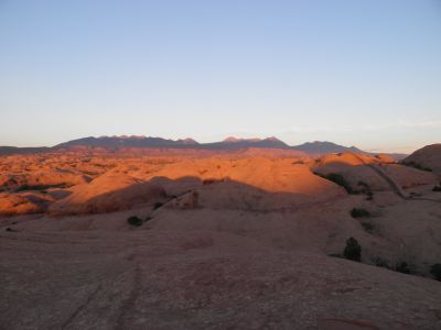
The last stop we made on top of
a cliff. Up here we enjoyed the sunset behind the rocks and could also enjoy the
sight of the sun's last rays on the La Sal Mountains southeast of Moab. Chad
(the father) had brought champagne with him for his family, but both Nick, as
well as Tim and I also were offered a taste.
When the sun had set, we returned to town, still in the slickrocks, still
off-road, but now in the dark. When we came back we gave Nick a good tip and
thanked him for the ride. Back at the hotel we went outside to enjoy the
magnificent starry sky. Without a cloud in the sky, and without artificial light
from street lamps a lot of stars were visible. When we entered the room again,
we discovered that we should not have left the door open. The whole room was
almost black with mosquitoes. Walls, curtains, mirrors, lamps, etc. We quickly
therefore went to bed and turned off the bed lights so they were not drawn to us.
- Return to Father and Son tour -
- Return to Travel
stories -