Eaten by mosquitos
 Next day we continued further north. We were going through the
northern part of Utah
the southeastern part of Idaho and northwestern part of Wyoming to Gardiner, Montana.
Next day we continued further north. We were going through the
northern part of Utah
the southeastern part of Idaho and northwestern part of Wyoming to Gardiner, Montana.
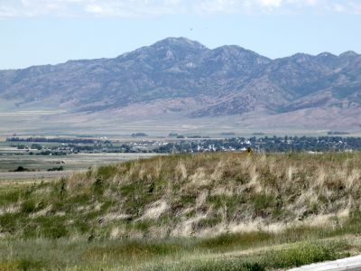
Some might wonder how come we visited Salt Lake City without going to Great Salt
Lake or the Salt Desert, but Tim was not particularly interested in the lake,
and felt, that he has seen enough desert for one vacation, and since I had seen
it before, I didn't insist. But on our way north on I-15 we could see the lake
in the distance from several spots.
We continued along I-15 through Idaho. Dorte and I drove through this state
twice in 2006, both in the southeast corner and through the northern panhandle.
Back then we made a single stop in a small town, Montpelier, in south-east
corner of the state, where we ate lunch. Here I had also took my only
picture from that state. It depicts Dorte outside the restaurant. I would do a
little better this time. For the first - and, indeed, only time on the trip, we crossed a state border on an
Interstate, and to show that I hadn't become a fanatic, we visited the local
Welcome Center. Tim thought that maybe I had been cured of the brochuritis which both
he and Tina previously believed that Dorte and I were suffering from after
our trip in 2000.
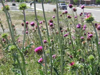
Unlike in 2006, we drove a longer stretch on our first trip
through Idaho, and I actually succeeded in getting some pictures of the
landscape. Our path led through the city of Pocatello, and from there through the Fort Hall
Indian Reservation, where members of the Bannock and Shoshone tribes reside. We
thought at first that it was a reservation for the Blackfoot tribe, as the city
Blackfoot is located just outside the reserve. I was a little confused, because
I knew that the Blackfoots has their reservation up in northern Montana, and it turned out later that the name
originated from a group of trappers that came to the area in 1818. In 1812, there had been a
forest fire, and the natives who lived here had to move around in the burned
areas. This dyed their moccasins black, which was the reason for the name.
 Shortly after Idaho Falls, we left the Interstate and and took U.S. Route 20 to
the northeast. In the small town of Rigby, we stopped and ate lunch. Here Tim
finally got his way and we ate at a Wendy's. This was a bad idea, but we didn't
know that then. Tim had a chicken burger and I had salad with fried chicken, and my guess
is that the chicken may not have been totally fresh. Again, I got a couple
of Idaho pictures before we continued north along U.S. 20 that would lead us all
the way to West Yellowstone and the west entrance to Yellowstone National Park,
whose northwest corner we would cross on our way to Gardiner. The road through
that part of Idaho was quite pretty and to the east we had a distant view of
the Teton Range, which we would later see from the east side and which are
regarded as one of America's most beautiful mountain ranges. Later the
landscape changed and we began to see more and more conifers and in several places we saw fire
warning signs which said that the fire risk was "Extreme". Earlier we had seen the risks
of "High" and "Very High" down in Arizona, but this was the first time it was so
high, and actually everything looked very dry.
Shortly after Idaho Falls, we left the Interstate and and took U.S. Route 20 to
the northeast. In the small town of Rigby, we stopped and ate lunch. Here Tim
finally got his way and we ate at a Wendy's. This was a bad idea, but we didn't
know that then. Tim had a chicken burger and I had salad with fried chicken, and my guess
is that the chicken may not have been totally fresh. Again, I got a couple
of Idaho pictures before we continued north along U.S. 20 that would lead us all
the way to West Yellowstone and the west entrance to Yellowstone National Park,
whose northwest corner we would cross on our way to Gardiner. The road through
that part of Idaho was quite pretty and to the east we had a distant view of
the Teton Range, which we would later see from the east side and which are
regarded as one of America's most beautiful mountain ranges. Later the
landscape changed and we began to see more and more conifers and in several places we saw fire
warning signs which said that the fire risk was "Extreme". Earlier we had seen the risks
of "High" and "Very High" down in Arizona, but this was the first time it was so
high, and actually everything looked very dry.
Because of Wendy's chicken, we had to make quite a
long stay when we came to the small,
very small town, Island Park. The village has only 215 inhabitants, and they live
right scattered, but the village had a gas station and a shop with a rest room. The store was obviously
meant for tourists, and while waiting for Tim I bought a bottle of wine,grown
and produced in
Idaho and I managed to bring it all the way back to Denmark. When we drank it
at home, it was drinkable, but is was not a great wine. Then I went
outside to take some pictures of the store, which also functioned as "town
hall". A branch of the Snake River, called the Henry's Fork ran just on the
other side of the road, so I also took some photos of that. The whole village is only 150
meters wide at the widest point. On the other hand the locals claims that the
city has the world's longest main street (33 miles).
When we had done, what we needed to do, we continued northeast and shortly before West
Yellowstone, we entered Montana. We entered Yellowstone National Park by
the western entrance, which actually is in West Yellowstone. Cutting the corner
through the park was the quickest way to Gardiner. Shortly after passing the
entrance, we left Montana again and entered Wyoming. It was the first
and only time on the trip, we visited four states on the same day. The road follows Madison River (one of the three
rivers that form the Missouri River), a long while. At Madison Junction the road from West Yellowstone, meets the 8-figure road through
the national park. This road is called Grand Loop Road. Here we headed along the northwestern arc of
the loop, to get to Gardiner. And voila - as soon as we
turned northwest, we drove into roadworks, where we had to stop and wait
for 20 minutes before we could continue. When the pilot car finally came back to pick us
up and lead us through a long queue had formed. It turned out that the pavement
had been removed, leaving only the gravel. Just behind the pilot car, a water
truck was busy watering the gravel, so when we finally had passed this stretch
of dirt road, our car
that had long been dusty, especially from the dirt road in Canyonlands,
was now completely muddy and more grayish brown than the original red color.
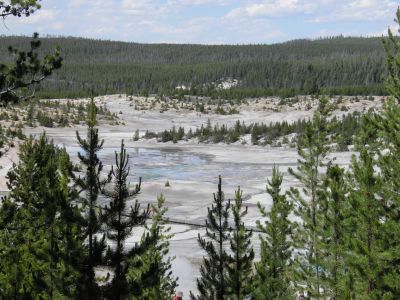 When we arrived at Norris Geyser Basin, Tim
needed another break. The chicken had hit him harder than me. We therefore drove into the parking lot,
where I in 2006 was "chased" by a large bison bull. You will get that story
another time. When Tim was finally able, we decided to take a
walk in through the 'Back Basin' part of Norris Geyser Basin. Here we saw the
world's tallest geyser, Steamboat Geyser, and while it was bubbling nicely, it
didn't erupt. It is very erratic and have not had any major eruptions
since 2005. We also passed a lot of other geysers, including the red-green Echinus Geyser,
the world's largest geyser with acidic water, Minute Geyser, which once erupted every minute
but was destroyed by tourists, who threw stones into the vent,
Puff'n Stuff Geyser , Pork Chop Geyser and many more. Unfortunately, none of those who
we visited, erupted while we were there, but this is often the case when you only have a short time
at a geyser.
Many of them erupts hours, days or months apart. Steamboat Geyser, mentioned above,
have once taken a break of 50 years between the two eruptions. In return, we saw
some hot springs that seethed and bubbled and smelled foul; among others Crater
Spring and Mystic Spring. As we approached the parking lot again, we enjoyed the
view over the lower part of Norris Geyser Basin, called Porcelain Basin because
of the colors. We didn't went down there but I went a bit down the path to look
at some fumaroles. Fumaroles are hot springs, where there is so little water and
so high
temperatures that they never erupts, because all the water evaporates before it
reaches the surface.
When we arrived at Norris Geyser Basin, Tim
needed another break. The chicken had hit him harder than me. We therefore drove into the parking lot,
where I in 2006 was "chased" by a large bison bull. You will get that story
another time. When Tim was finally able, we decided to take a
walk in through the 'Back Basin' part of Norris Geyser Basin. Here we saw the
world's tallest geyser, Steamboat Geyser, and while it was bubbling nicely, it
didn't erupt. It is very erratic and have not had any major eruptions
since 2005. We also passed a lot of other geysers, including the red-green Echinus Geyser,
the world's largest geyser with acidic water, Minute Geyser, which once erupted every minute
but was destroyed by tourists, who threw stones into the vent,
Puff'n Stuff Geyser , Pork Chop Geyser and many more. Unfortunately, none of those who
we visited, erupted while we were there, but this is often the case when you only have a short time
at a geyser.
Many of them erupts hours, days or months apart. Steamboat Geyser, mentioned above,
have once taken a break of 50 years between the two eruptions. In return, we saw
some hot springs that seethed and bubbled and smelled foul; among others Crater
Spring and Mystic Spring. As we approached the parking lot again, we enjoyed the
view over the lower part of Norris Geyser Basin, called Porcelain Basin because
of the colors. We didn't went down there but I went a bit down the path to look
at some fumaroles. Fumaroles are hot springs, where there is so little water and
so high
temperatures that they never erupts, because all the water evaporates before it
reaches the surface.
We continued further along the northwestern branch of Grand Loop Road and passed Obsidan
Cliff, and onwards to Mammoth Hot Springs. Again we went
for a short walk, and and then drove the car around what is called the
Upper Loop. Mammoth Hot Springs is completely different from anywhere else in
the park. Here percolating calcareous water sprinkles out of the ground. The
water has formed some very nice terraces and other formations. The limestone
dissolves in the water on its way up through the rock to the surface, and then
is deposited again on the surface, so you can say that the earth is turning
inside out.
Below the Mammoth Hot Springs is one of the national park "villages", Mammoth
Hot Springs Village, where there are hotels and much more. Here you find the park
rangers' headquarters and here is Fort Yellowstone, a fortress from the
days when the national park was established in the late 1800's. It was the
world's first national park, and then there was nothing called the National
Park Service. The protection and surveillance of the park was therefore left to
the army, who built the fort. The barracks are currently used as housing for
those working in the park. We continued
to the park's northern entrance/exit and the city of Gardiner (at this time we were back in
Montana), where we easily found our hotel which was the same one where Dorte and I
had stayed four years earlier.
After our accommodation we had dinner at the restaurant, located right next to
the hotel, Yellowstone Mine Restaurant. Tim got his first taste of bison meat, when he ordered a bisonburger while
I simply satisfied myself with barbecue baby back ribs. The first of the kind I had on this
trip.
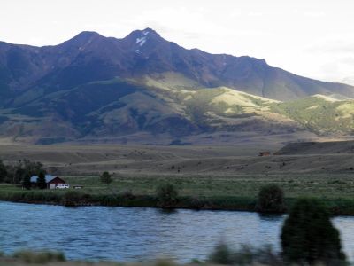 When we
were done eating, I suggested that we should go little further
north along U.S. Route 89 so I could get
some pictures from Montana. I didn't have a single photo from that state
from our first visit. We drove north to the town of Livingston, where we turned around and
drove back. On this trip we drove past Mount Cowen, which is 11,000 feet high. The mountain however
do not look particularly tall because you already are more than 6,500 feet above
sea level. Near the town of
Play (Route 89 bypasses the towns on this route), we found a gas station where we decided to fill up the car before we
drove back to the hotel so it was ready for the big tour of the national park,
the next day. However,
it was a very bad decision in a valley stretching along the Yellowstone River.
Play was in the middle of a rather damp meadowland. So when I began filling gas
on the car, we were both assaulted by roughly 3 billion mosquitoes, and when
with the fuel hose in the filler neck and being busy filling up it is very
difficult to escape. Tim ran into the store so he got off a little cheaper than me,
but my face and neck and my arms and legs had mosquito bites enough for both of us.
I almost had to have have a blood transfusion when they were through. Actually, I spent much of the rest of
our vacation not locating a pharmacy,
where they sold anti-itch agent, and when I finally found it, the itching had
stopped. At the time I had not yet heard that Atamon is good against itching
from mosquito bites. It is, believe me! I have used it several times
after returning to Denmark and it works. I also do not know whether you can buy Atamon in the U.S
(it is actually a preservative based on sodium benzoate and used for preserving
pickled vegetables and marmelade and stuff like that). But now I do know and
next time I think I will bring a bottle Atamon with me in my a suitcase. And as it preserve,
it might preserve me too, so I will never look any older. Just an added value :-).
When we
were done eating, I suggested that we should go little further
north along U.S. Route 89 so I could get
some pictures from Montana. I didn't have a single photo from that state
from our first visit. We drove north to the town of Livingston, where we turned around and
drove back. On this trip we drove past Mount Cowen, which is 11,000 feet high. The mountain however
do not look particularly tall because you already are more than 6,500 feet above
sea level. Near the town of
Play (Route 89 bypasses the towns on this route), we found a gas station where we decided to fill up the car before we
drove back to the hotel so it was ready for the big tour of the national park,
the next day. However,
it was a very bad decision in a valley stretching along the Yellowstone River.
Play was in the middle of a rather damp meadowland. So when I began filling gas
on the car, we were both assaulted by roughly 3 billion mosquitoes, and when
with the fuel hose in the filler neck and being busy filling up it is very
difficult to escape. Tim ran into the store so he got off a little cheaper than me,
but my face and neck and my arms and legs had mosquito bites enough for both of us.
I almost had to have have a blood transfusion when they were through. Actually, I spent much of the rest of
our vacation not locating a pharmacy,
where they sold anti-itch agent, and when I finally found it, the itching had
stopped. At the time I had not yet heard that Atamon is good against itching
from mosquito bites. It is, believe me! I have used it several times
after returning to Denmark and it works. I also do not know whether you can buy Atamon in the U.S
(it is actually a preservative based on sodium benzoate and used for preserving
pickled vegetables and marmelade and stuff like that). But now I do know and
next time I think I will bring a bottle Atamon with me in my a suitcase. And as it preserve,
it might preserve me too, so I will never look any older. Just an added value :-).
When we got back to the hotel with mosquito bites and all, we just checked whether the Internet was still there and
it was. And the world had not gone astray any more than usual while we had turned
our backs to it.
- Return to Father and Son tour -
- Return to Travel
stories -