Above ground, on ground and underground
This would prove to be one of those days, where we should have stayed in bed. We got on the the wrong ferry, couldn't find our hotel and got a parking ticket, all on the same day.
Mountain high, hotel gone
The day began well enough. We were going to leave the Twilight Zone and return to civilization in Seattle. We headed north and east on Route 101 to the small town of Port Angeles, located on the north coast of the Olympic Peninsula. Along the way we stopped once by Crescent Lake to take some pictures, of which one will be used for my 2013 calendar. In Port Angeles, we left the highway and headed south to Olympic National Park once more, this time to an area called Hurrican Ridge. Here we could experience mountains, alpine meadows, beautiful views of the Juan de Fuca Strait and much more according to our brochure. The road up to Hurricane Ridge was a mountain road with some "pull-outs", where you could enjoy the view. We, however, agreed to drive all the way to the top and then visit the various pull-outs on our way down.
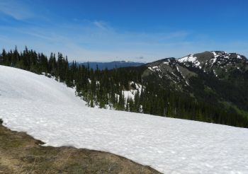 When we reached the top, there was a large car park and
a Visitor Center. Several hikes in the mountains start here,
but we were content with a short walk along a paved path, first to a view
point where we really could enjoy the views of the Olympic Mountains, including Mount Olympus,
the highest peak in the range which is 7,979 feet high.
When we had enjoyed the view for a bit we continued along the paved path until it
was completely covered with frozen snow drifts. From there we took a different path back
to the parking lot. Along the way we saw a lot of black-tailed deer grazing near
the path. When we finally got back to the parking lot, I began to feel a little
cold - despite
the sunshine. I was wearing shorts and T-shirt, while Tim
also wore his incessant vest, so we went down to the Visitor Center to get warmed
up. We didn't stay long, but went back to the car and began the descent. When we
got back to the car, I checked the outdoor thermometer, and it showed that the
temperature was about -15° F, so no wonder that it had felt cold.
This later proved to be the lowest temperature on the whole trip.
When we reached the top, there was a large car park and
a Visitor Center. Several hikes in the mountains start here,
but we were content with a short walk along a paved path, first to a view
point where we really could enjoy the views of the Olympic Mountains, including Mount Olympus,
the highest peak in the range which is 7,979 feet high.
When we had enjoyed the view for a bit we continued along the paved path until it
was completely covered with frozen snow drifts. From there we took a different path back
to the parking lot. Along the way we saw a lot of black-tailed deer grazing near
the path. When we finally got back to the parking lot, I began to feel a little
cold - despite
the sunshine. I was wearing shorts and T-shirt, while Tim
also wore his incessant vest, so we went down to the Visitor Center to get warmed
up. We didn't stay long, but went back to the car and began the descent. When we
got back to the car, I checked the outdoor thermometer, and it showed that the
temperature was about -15° F, so no wonder that it had felt cold.
This later proved to be the lowest temperature on the whole trip.
On the way down from the mountains we stopped at two or three pull-outs and took some pictures. On one of these pull-outs we were promised views of the Juan de Fuca Strait, and we could indeed see strait in the far distance, but it was somewhat distorted because of the mist. When got down to Port Angeles once again, we had to fill up the car with gas for the first time on this trip. This gave us our first, or rather big surprise when we noticed the price of petrol. It turned out that gasoline cost $ 3.99 per. gallon - a far bit more than on our last trip in 2010. At that time we were happy driving a Toyota Camry and not the Chevy Camaro we had rented two years earlier. Later we met gas prize of more than $ 4 per. gallon, but as we headed east, the prices got lower again, and somewhere in South Dakota, we acutally only paid $ 2.95 per. per gallon. We continued on along Route 101, toward Seattle. The plan was that we would go via Bainbridge Island and from there take a ferry to the city, but even with the help of our GPS, we managed to end up somewhere else, as the GPS used the fastest route at lead us to the town of Kingston on another island, offering a ferry connection across Puget Spound, but not to Seattle. Instead it went to Edmonds, somewhat north of Seattle. The reason I would have liked to visit Bainbridge Island was because of the winery on the island. However, as we had arrived at a port, we decided just to stay in Kingston and wait for the next ferry.
 The
ferry trip lasted approx. half an hour, and we stayed in the car for the durance
of the trip. Well in Edmonds we headed for Interstate 5 and followed this around 12 miles south
to Seattle, where we had booked a hotel from home. We easily found the right exit
from the interstate, but then our problems began. Before leaving Denmark, I have
printed all our hotel booking confirmations, placed them in a folder, along with other papers that we might
also need along
the way. Before we left Forks, I had removed this particular confirmation from the folder,
so that it was easily accessible when we got to the hotel, but for some reason
it was not anywhere in the car. I
had apparently left it at our hotel in Forks. Normally we didn't need the
cofirmation at check in time, but our problem was, that we didn't remember the
address of the hotel that we had booked! I did, however, remember that the hotel was either a Comfort
Inn or a Comfort Suites, and that it was situated in the vicinity of Seattle
Center. Our faithful GPS could didn't know any Comfort Suites in the area, but
there should be a Comfort Inn near Seattle Center. We asked the lady in the box
for guidance, and she guided us to a hotel all right. It was not a Comfort Inn
though, but something quite different, so Tim and I decided, that the GPS was
wrong - which it actually was. We there drove around the area around Seattle
Center for almost an hour without locating any Comfort Inn.
The
ferry trip lasted approx. half an hour, and we stayed in the car for the durance
of the trip. Well in Edmonds we headed for Interstate 5 and followed this around 12 miles south
to Seattle, where we had booked a hotel from home. We easily found the right exit
from the interstate, but then our problems began. Before leaving Denmark, I have
printed all our hotel booking confirmations, placed them in a folder, along with other papers that we might
also need along
the way. Before we left Forks, I had removed this particular confirmation from the folder,
so that it was easily accessible when we got to the hotel, but for some reason
it was not anywhere in the car. I
had apparently left it at our hotel in Forks. Normally we didn't need the
cofirmation at check in time, but our problem was, that we didn't remember the
address of the hotel that we had booked! I did, however, remember that the hotel was either a Comfort
Inn or a Comfort Suites, and that it was situated in the vicinity of Seattle
Center. Our faithful GPS could didn't know any Comfort Suites in the area, but
there should be a Comfort Inn near Seattle Center. We asked the lady in the box
for guidance, and she guided us to a hotel all right. It was not a Comfort Inn
though, but something quite different, so Tim and I decided, that the GPS was
wrong - which it actually was. We there drove around the area around Seattle
Center for almost an hour without locating any Comfort Inn.
However, on my website I had linked to the websites of all the hotels, we had booked from home, so if I could get online, our problems would be solved. As we passed a Quality Inn & Suites (for the third time on our trip around the area), a Choice Hotel like Comfort Inn, we decided to park the car and while Tim did at this, I visited the hotel to ask if I could borrow a PC so I could get online. I told the front desk that I could not remember exactly which hotel I had booked, and they were kind snough to let me borrow the PC. I logged on the Internet and discovered that it was my memory, that had failed us. We hadn't booked a room in a Comfort Inn, but - ta dah - in the very same Quality Inn & Suites, where I was now looking for the hotel, and which we had already passed three times. I went back to the front desk and could inform them, that I actually have a reservation for two nights threre. However, they could not find me in the system and the desk clerk asked me if I had a reservation number. As the missing reservation was the cause of all the problems and the copy of our confirmation was 7,000 miles away in Denmark, I couldn't help him. It was by the way the only time any hotel asked for a reservation number on the entire trip. Eventually, however, he finally managed to locate the booking. In the U.S., Jan is typically a girl's name, and therefore I was recorded as Ms. Jan Kronsell and despite the fact that I had spelled the surname to him, he was looking for Mr. Cronsell. When he found that I actually had a reservation, he told me that our room was not ready yet, which we hadn't expected either as it was not yet 3 pm. I asked if there was somewhere we could park the car and and he told us that we could right outside the hotel.
I picked up Tim and we drove to the hotel parking lot and parked the car, then walked out to take a look at town. We walked up to the Seattle Center, from where we rode the city's monorail into downtown, a 90 second ride. It took us to Westlake Center, a shopping mall in downtown at 5th Avenue. From here we went down to Pike Place west of 1st Avenue, and when I say that we went down, I mean it literally. Seattle is located on a steep slope, so from the waterfront the streets rise steeply up to Pike Place and then less steep, but still uphill to oiher streets in the city. As we were going in the opposite direction, it was downhill.
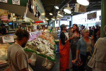
 We visited Pike Place Market,
walking through the market, just looking. At the far end we emerged at a small
park, named Victor
Steinbrueck Park. Here we enjoyed the view of Elliott Bay, in
addition to sight of the many people who were sunbathing on the lawn.
We walked back through the market to the entrance, where we originally
entered. Here we spent a little time enjoying the entertainment at Pike Place Fish
Company (World Famous) and talked a bit with one of the fishmongers, who of
course wanted to know where we came from, what we told him, and who wanted to
sell us some fish, which we didn't buy on that occation. We left the market again and began
looking for a bookstore.
With help from a local hotdog vendor, we managed to locate a Barnes & Noble. Here we spent
about an hour or so, and we both left with a small selection of
books for the trip.
We visited Pike Place Market,
walking through the market, just looking. At the far end we emerged at a small
park, named Victor
Steinbrueck Park. Here we enjoyed the view of Elliott Bay, in
addition to sight of the many people who were sunbathing on the lawn.
We walked back through the market to the entrance, where we originally
entered. Here we spent a little time enjoying the entertainment at Pike Place Fish
Company (World Famous) and talked a bit with one of the fishmongers, who of
course wanted to know where we came from, what we told him, and who wanted to
sell us some fish, which we didn't buy on that occation. We left the market again and began
looking for a bookstore.
With help from a local hotdog vendor, we managed to locate a Barnes & Noble. Here we spent
about an hour or so, and we both left with a small selection of
books for the trip.
It was now almost half past five, and as we had not had any lunch, we were a little hungry. We decided to stay in town and eat an early dinner at a Hard Rock Cafe, which we had passed on the way to the bookstore. We therefore went back to the restaurant and had dinner there. After dinner we struggled back up the hill to the monorail and rode back to Seattle Center. Here we walked the half a mile back to the hotel where our room was now ready, so we got the key and a token to be placed in the car, to show that we had paid our parking fee! We went out to get our suitcases and discovered that there already was a note under the windshield wiper. It was a little greeting from the parking company that asked us to pay $ 43 within 14 days, otherwise there would be added an additional $ 30 per. week until we paid. When we got to the room I tried to pay, but the website would not accept addresses outside USA, so I could not use my credit card. I therefor went to the front desk, to ask what to do, and as it was the same guy, that I had spoken to earlier on, he claimed that it was his fault ad he had misunderstood my question earlier, and should have given me the token, the first time i was there, so the hotel paid the ticket, and thus saved me 43 dollars.
The Seattle way
The next day we were staying in Seattle and it later proved to be the only day, that we didn't use our rented car at all. It was planned to be our "major sightseeing day" in Seattle, and that it was.
 We
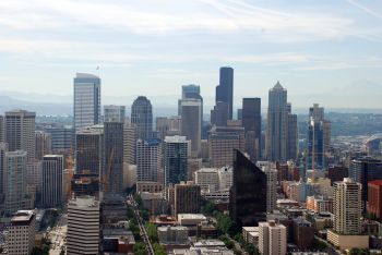
started by walking to Space Needle so early that we could be there when it
opened, to avoid standing in a too long line for tickets. When we got there only
four or five people were ahead of us, and when the ticket office opened, we
bought our tickets and went to the elevator. The elevator ride to the viewing
platform, 525 feet above ground lasted 90 seconds. Well up, we spent approx. an hour enjoying the views
of the city and the harbor and to take pictures of same, also there were nice views of Puget Sound, Olympic
Peninsula and the Cascade Mountains. The observation deck has an indoor
section with a "balcony" all the way around, so when we were done
looking at everything from the balcony, we went inside and I had a cup of
coffeee, while Tim enjoyed a bottle of water.
We
started by walking to Space Needle so early that we could be there when it
opened, to avoid standing in a too long line for tickets. When we got there only
four or five people were ahead of us, and when the ticket office opened, we
bought our tickets and went to the elevator. The elevator ride to the viewing
platform, 525 feet above ground lasted 90 seconds. Well up, we spent approx. an hour enjoying the views
of the city and the harbor and to take pictures of same, also there were nice views of Puget Sound, Olympic
Peninsula and the Cascade Mountains. The observation deck has an indoor
section with a "balcony" all the way around, so when we were done
looking at everything from the balcony, we went inside and I had a cup of
coffeee, while Tim enjoyed a bottle of water.
When we returned to groundlevel, we spent some time in the souvenir shop where the elevator strangely enough had it's lower terminus. Then we walked to the monorail, bought a return ticket, and rode to downtown once again. As the day before we went down to Pike Place Market and strolled around the market, but not for long. We located the Soundview Café where Dorte and I had eaten lunch at in 2006, and so did did Tim and I. An early lunch though, as the clock was only about 11 am, but we were hungry as we hadn't had any breakfast. After lunch we visited the lower floors of the market where mostly antiques, handicrafts and such are sold. From here we continued down to the bottom, crossed the road and visited the Seattle Aquarium. It was a much more positive experience than rhe aquarium in Monterrey, California, that we had visited in 2010. Congratulations Seattle, you have managed to establish an aquarium, not an entertainment park. We spent a little more than an hour in the aquarium and of course saw lots of fish, but also birds, sea otters and other mammals, such as divers, feeding fish.
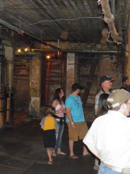
After the visit to the aquarium, we returned to Pike Place Market and took the elevator up to the top floor. From here we walked to 1st Avenue and followed it to Pioneer Square, which was once the center of the city and also the center of its original business, namely the timber industry. At Pioneer Square you can buy tickets for tours of the city's underground, so that we did. By luck, the next tour was about to depart, so we were hurried into a neighboring room. Here we had a lecture on Seattle's history and the story on how the "underground" was created. We also got the story about why it's a bad idea to have sewers, which opens just below the high-water mark when you have just introduced water closets and other interesting stories about how they had done things "The Seattle Way", that is - as our lecturer explained - "the wrong way".
The town houses were originally built of wood but in 1889 most of the city burned down (31 street blocks). No one was hurt and the city officials found it a good opportunity to "start all over", and build Seattle 2.0, which they did, but unfortunately once more "the Seattle way". Before the fire streets often became so muddy, when the tide rose, that dogs and small children could be sucked down into the mud and drown. Of course the townpeople wanted to avoid that, so they filled the streets with what they had most, namely sawdust from the sawmill that was lying around in large piles. Unfortunately they all overlooked, however, that sawdust tend to collapse when it becomes wet, making the streets even worse that before and it also burns well, so the sawdust in the streets made the fire worse. Another problem was the lack of water. There was not enough pressure in the water lines for the fire hoses to work and it was impossible to get water from Puget Sound, as it was low tide during most of the fire and there is a fairly strong tides in Puget Sound. Therefore, after the fires, only houses biuld of stone were allowed.
 Still
there was the problem with the muddy streets. To solve that walls were built between streets and sidewalks, and
the space between these walls were filled with rocks that do not collapse, when
wet. This raised the streets 15 feet or more, making sure they would not get
flooded and muddy again. The new stone houses were built with two entrances, one on the ground floor and
one on the second floor, because people figured that the sidewalks at some later time would also
be raised, so that the ground floor would become basement and the second floor would
become ground floor. As the doors on the ground floor were only meant to be
intermediate, the door openings on the second floor were mad much more beautiful.
Shops were still on the then ground floor, so while the streets were raised,
the sidewalks remained where they were. This meant that from the sidewalk, there were
about 15 to 30 feet up to street
level, and of course the same heeight to get down again when you had crossed the
street. To make it
possible for people to even cross the streets, long ladders were placed on
both sides of the street. When the women were going from one side of the street
to the other, they had to climb
up a ladder in their long skirts with shopping bags in their hands, and down again on the other side, which could be a risky venture. On the other hand,
there were reportedly never a shortage of men who would help hold the ladders
whenever a woman needed to cross! But unfortunately also pubs were at sidewalk level,
so also quite drunk men had to climb the ladders to get home after a night of
drinking. In a single year (I
don't remember which year it was), 18 people were killed by falling from ladders. This
wouldn't do much good for the city's brand, so the deaths were recorded as "involuntary suicide".
Later "ceilings" were built over the sidewalks, and on these "ceilings" new
sidewalks were contructed, and the old sidewalks below became tunnels beneath the city, and it is these
tunnels, which today form Seattle Underground. Access to them was closed in 1907
because it was feared that rats in the tunnels could spread bubonic plague, but
they were opened to tourists again in 1965 and is today a major attraction.
Still
there was the problem with the muddy streets. To solve that walls were built between streets and sidewalks, and
the space between these walls were filled with rocks that do not collapse, when
wet. This raised the streets 15 feet or more, making sure they would not get
flooded and muddy again. The new stone houses were built with two entrances, one on the ground floor and
one on the second floor, because people figured that the sidewalks at some later time would also
be raised, so that the ground floor would become basement and the second floor would
become ground floor. As the doors on the ground floor were only meant to be
intermediate, the door openings on the second floor were mad much more beautiful.
Shops were still on the then ground floor, so while the streets were raised,
the sidewalks remained where they were. This meant that from the sidewalk, there were
about 15 to 30 feet up to street
level, and of course the same heeight to get down again when you had crossed the
street. To make it
possible for people to even cross the streets, long ladders were placed on
both sides of the street. When the women were going from one side of the street
to the other, they had to climb
up a ladder in their long skirts with shopping bags in their hands, and down again on the other side, which could be a risky venture. On the other hand,
there were reportedly never a shortage of men who would help hold the ladders
whenever a woman needed to cross! But unfortunately also pubs were at sidewalk level,
so also quite drunk men had to climb the ladders to get home after a night of
drinking. In a single year (I
don't remember which year it was), 18 people were killed by falling from ladders. This
wouldn't do much good for the city's brand, so the deaths were recorded as "involuntary suicide".
Later "ceilings" were built over the sidewalks, and on these "ceilings" new
sidewalks were contructed, and the old sidewalks below became tunnels beneath the city, and it is these
tunnels, which today form Seattle Underground. Access to them was closed in 1907
because it was feared that rats in the tunnels could spread bubonic plague, but
they were opened to tourists again in 1965 and is today a major attraction.
After the lecture we were shown around in the underground. Not all the tunnels are connected, so we visited three tunnel systems, with a short walk on the street between each. The guy who showed us around was called Rich and he told us even more stories from Seattle's past, some probably more true than others. We heard among others of brothel owner Lou Graham, who is the individual who has donated the largest amount of money to the Seattle school system, more money than the city's wealthy gentlemen of the time donated all together. Even if these wealthy gentlemen were frequent patrons of Mrs. Grahams services, she was never respected in town. She was still an institution though. After a false arrest, which ended up forcing the mayor to resign, all police officers had to salute here whenever they met her on the street, and young businessmen who wanted to be accepted by colleagues had to regularly visit her establishment. In fact prostitution flourished in Seattle during this era. At a time when the city had about 10,000 inhabitants, approx. 4,000 of these were women. Of these 4,000 women, 2,500 were registered as "seamstresses". Incredibly how many dresses, the last fifteen hundred woman used if one assumes that the seamstresses made their own clothes.
After the visit to the underground we went back to Pike
Place Fish. The guy we had spoken to the day before, recognized us and came to
us with a "Oh, My Danish Friends". This time we rewarded him by buying some
cans of excelent
smoked salmon to bring home to Denmark. After the visit at the market we went
back to Westlake Park and the monorail for the
last time and rode it back to Seattle Center and our hotel. Next morning we were
going east en earnest.
-
Return to Cross Country Tour -
- Return to
Travel stories -