The roadtrip begins
As Tim put it, the day we left Seattle were to be the first real day of our roadtrip as for the first week we hadn't moved much around. But on this day we were beginning our trip east. The first couple of days we were heading more or less straight east through Washington, Idaho and Montana.
Bavarian atmosphere
 From
Seattle we headed north and then turned east on Route 2, through farmlands, but
as we got further east the landscape turned more and more mountainous, and we
started to climb Casacade Range. At Stevens Pass we reached the high point of
the first day's trip at around 4,000 feet, but as there was not much to see, we just continued down the other side of the mountains towards the town of
Wenatchee. Descending the mountains, we drove along the Wenatchee River, which
had a lot of rapids, and we made a few stops to take pictures. About halfway
down the mountain, we took a lunch break Leavenworth.
From
Seattle we headed north and then turned east on Route 2, through farmlands, but
as we got further east the landscape turned more and more mountainous, and we
started to climb Casacade Range. At Stevens Pass we reached the high point of
the first day's trip at around 4,000 feet, but as there was not much to see, we just continued down the other side of the mountains towards the town of
Wenatchee. Descending the mountains, we drove along the Wenatchee River, which
had a lot of rapids, and we made a few stops to take pictures. About halfway
down the mountain, we took a lunch break Leavenworth.
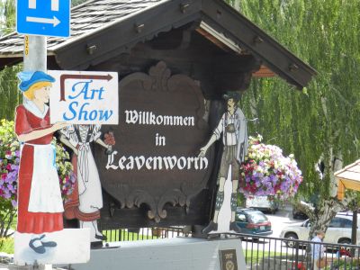
Leavenworth is an interesting city. It has less than 2,000 inhabitants, but for
some reason seems larger. A part of the city is deliberately laid out as a
Bavarian alpine village (inspired by the "Danish village" Solvang in California)
and at the entrance to the city you are met with a sign saying "Wilkommen in
Leavenworth" not Welcome to Leavenworth. Dirndl and lederhosen are mandatory
attire for all inhabitants! (Only joking). The city also sports a Nutcracker
Museum with more than
5,000 different nutcrackers. We didn't visit the museum though but continued to
Wenatchee after lunch. In Wenatchee we did some shopping then continued on Route
2 towards Spokane.
We continued to Spokane with good speed and a only a few breaks; one in Coulee
City where we passed a dam and a lake and stopped to take pictures. Near Spokane,
the largest city in eastern Washington (just over 200,000 inhabitants), we
switched to I-90, which we then took the last few miles to the Idaho border. We
didn't made any more stops until we reached the small town of Wallace, where we
decided to stay for the night.
A visit at the Center of the Universe
 Wallace
is a small town with less than 800 inhabitants. 784 the sign said at the
entrance to town. On the other hand it doesn't hide it's light under a bushel.
The town claims to be "silver capital of the world". Actually the town was
central in what is known as "the Coeur d'Alene silver district," which was
the most productive silver area in the United States, and one of the places in
the world where most silver has been dug. The historic downtown still looks
partly like a mining town from the 18th century and several buildings in downtown is on the National Register of Historic Places and thus declared worthy
of preservation. We would have visited the Sierra Silver Mine, but unfortunately
we arrived too late, and the next day, we had left town before the tours
commenced. The town also boasts af a bordello museum but this too was
closed, when we arrived. Instead we took a stroll on Main Street to get some
dinner.
Wallace
is a small town with less than 800 inhabitants. 784 the sign said at the
entrance to town. On the other hand it doesn't hide it's light under a bushel.
The town claims to be "silver capital of the world". Actually the town was
central in what is known as "the Coeur d'Alene silver district," which was
the most productive silver area in the United States, and one of the places in
the world where most silver has been dug. The historic downtown still looks
partly like a mining town from the 18th century and several buildings in downtown is on the National Register of Historic Places and thus declared worthy
of preservation. We would have visited the Sierra Silver Mine, but unfortunately
we arrived too late, and the next day, we had left town before the tours
commenced. The town also boasts af a bordello museum but this too was
closed, when we arrived. Instead we took a stroll on Main Street to get some
dinner.
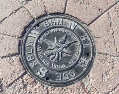
If you have seen the movie Dante's Peak with Pierce Brosnan and Linda Hamilton,
you know the main street of Wallace. The movie was partly filmed in this city, and
the main street appears in some scenes. When we had eaten, we went back to
Main Street, actually out in the middle of the intersection next to the
restaurant. This place is the center of the universe, and we would like to take
a look. Who wouldn't? Actually it is not the center of the intersection, that is
the center of all the known and unknown universe, but a manhole, which is
somewhat offset from the center of the intersection. This manhole has been the
center of the universe since September 25th, 2004, when the local mayor declared
it as such. The manhole got a new cover with an appropriate text and of course
I had to take a picture.
A repeating river
After the visit to Wallace we were going to Glacier National Park in Montana and Going-to-the-Sun Road, which at least by some people, is considered to be the world's most beautiful road.
We continued along I-90 into
Montana - and a little further on to Missoula. On the way from Idaho to Montana,
the interstate crosses Bitterroot Mountains at Lookout Pass. The pass is 4,700 feet
above sea level and when you pass the highest point, you also pass the state
border between Idaho and Montana. Here we had to adjust our watches as we
passed from Pacific time to Mountain time.
In 2006, when Dorte and I drove in the opposite direction from Missoula to
Seattle, we had noticed Clark Fork, as the highway regularly crossed this river.
This time I had therefore set myself to count how many times we actually crossed
the river. From the border to Missoula Tim and I crossed it 12 times and the
river continues along the interstate even after Missoula. In Missoula we turned north along Route
93, which passes through the Flathead Indian Reservation. In the town of Polson
we left Route 93 to take a route east of Lake Flathead. Montana Road 35, which
leads east of the lake, were marked as a Scenic Byway and it was a nice drive
along the lake, where we stopped a couple of times to take pictures. North of
the lake, we met with Route 2 once more, and we stayed on "the two" the rest of
the way to the very small town of West Glacier, where we had planned to spend the
night. West Glacier is located 3,169 feet above sea level and is so small that
its population are not counted independently of the census.
When we found our motel in West Glacier, it was at only a quarter to two in the afternoon so we took a short drive into the national park (about 20 miles) before we turned back. On the way, we took some pictures of Lake McDonald and McDonald Creek before returning to the motel. That would give us more time to enjoy Going-to-the-Sun Road the next day.
A road
When we left West Glacier the
next day, we had only planned a relatively short drive, but the masters of the weather had other plans, and the trip would end up being quite long. The main
purpose of the trip was a drive along Going-to-the-Sun Road through Glacier
National Park from West Glacier, where we lived to Saint Mary on the eastern
side of the mountains. From there we would drive to Browning in the Blackfoot
Reservation and stay there for the night.
 The
first 20 miles into the park, we had already seen the day before, so we could
concentrate on the last (and most beautiful) 30 miles through the park along
Going-To-The-Sun Road, which is considered one of the world's most beautiful
roads (some Americans consider it to be the most beautiful) and as we left the
motel quite early there were not so many people in the park, which was what we
had expected. On the other hand, it was cloudy with a drizzle on and off.
The
first 20 miles into the park, we had already seen the day before, so we could
concentrate on the last (and most beautiful) 30 miles through the park along
Going-To-The-Sun Road, which is considered one of the world's most beautiful
roads (some Americans consider it to be the most beautiful) and as we left the
motel quite early there were not so many people in the park, which was what we
had expected. On the other hand, it was cloudy with a drizzle on and off.
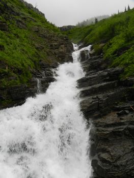
As we ascended the mountains the clouds became more and more heavy, and at times
we had clouds both above and below us, and at other times we were inside them,
so we could only drive with a speed of 10-15 miles per hour and it was so-so
with the beautiful views. At one time we were stopped by road works for around
20 minutes, but at that time it was impossible to see anything but the car
in front of us because of fog. Despite the bad weather we stopped in several
places to take pictures of the cloudy mountains, waterfalls etc. Before leaving
Denmark we had read that parking at the road's highest point, Logan Pass at
6,646 feet, would normally impossible if you arrived after 10 o'clock in the
morning in July. Nothing, however, could be more wrong the day we were there.
There was virtually only 10 cars throughout the several hundred cars big parking
lot. We did park though, and went up to the site Visitor Center, where we could
see pictures of the pass on "better" days, read about the road and so on. Here we
were also warned to eat food in the parking lot as local bighorn sheep had begun
to attack tourists to steal their food. As we were not planning to eat, it was
not problem to us though :-). At Logan Pass we passed the Continental Divide and
were now on the eastern side of Rocky Mouintains.
As we drove down from the mountains the clouds thinned. It was still cloudy and
foggy, but now we could see what was going on, and we stopped again in some
places to photograph rivers, lakes, mountains and glaciers, so even if the
weather didn't allow us the views we had hoped for, it was still an interesting
and exciting trip.
When we came down from the Going-to-the-Sun Road the landscape changed
and became prairie. At the same time the clouds disappeared completely and the
temperature rose considerably from the 50 degrees that had been on top of Logan
Pass. We were now in Blackfeet country, or at the least within the boundaries of
the Blackfeet Indian Reservation, and it was in the tribe's capital, Browning,
that we had expected to spend the night as we had figured on spending most of
the day inside the park. The bad weather did, however, that we did not spend
that much time in the park, so when we reached Browning, it was only noon,
making it a little early to stop for the night. We therefore decided to continue
for as long as we felt like it. We took a break at a gas station in
Browning though, to get a cup of coffee.
A river
 From
Browning we continued through cattle country (black feet are today mainly
pastoralists) by another "old friend", namely U.S. Route 89, which we have used
in both 2006 and 2010 as well. Our first goal was Great Falls, Montana. This
town is named after waterfalls on the Missouri River, which flows through the
city. It was not the waterfall we were interested to see though, but the big
fresh water spring, Giant Springs, located north of the city. The spring turned
out to be in Giant Springs State Park. Here we had to pay $ 5 to park our car
while it was free to Montana residents.
From
Browning we continued through cattle country (black feet are today mainly
pastoralists) by another "old friend", namely U.S. Route 89, which we have used
in both 2006 and 2010 as well. Our first goal was Great Falls, Montana. This
town is named after waterfalls on the Missouri River, which flows through the
city. It was not the waterfall we were interested to see though, but the big
fresh water spring, Giant Springs, located north of the city. The spring turned
out to be in Giant Springs State Park. Here we had to pay $ 5 to park our car
while it was free to Montana residents.
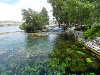
When we had parked the car, we went down to look at the spring, which is fairly
large and productive. The water has a temperature of 54 degrees year round. Cold
water springs are rarely particularly large, but this "produces" about 1,850
gallons of water every second. The water from the spring has fallen as
precipitation in the Little Belt Mountains about 60 miles away 2,900 years
before it reaches the spreing, so it's old water! Yet some of it is bottled and
sold as new :-). Some of the water overflows and spills into the Missouri River!
A portion of the drain occurs through Roe River, which used to be the world's
shortest river, only 200 feet long. At least it was until the Guiness Book of
Records abolished this category in 2006.
From Great Falls we continued to Billings, Montana's largest city, where we
decided to spend the night. Billings was planned to be the goal of next days
trip, so we were now a day ahead of our plan. That day we decided to use in South Dakota.
-
Return to Cross Country Tour -
- Return to
Travel stories -