The only National Park in New England
 We
left Boston heading for I-95 north. We followed the
interstate to the border between Massachusetts and
New Hampshire.
After a short stay at a rest area, we continued
through New Hampshire without stopping.
The interstate is a toll road through the state, so
we stopped at a toll booth when we entered, and when
we left the state once more, but beside from that,
we didn't stop at all in New Hampshire.
The entire journey through New Hampshire is only
about 15 miles or so, so we virtually exited the
state again before we recognized that we had entered.
Shortly after the passing the Maine border I-95
becomes a toll road again, so we had to pay up for a
second time, but the amount was still under $ 2.
After crossing the border, we visited the first and
only welcome center on this trip.
We
left Boston heading for I-95 north. We followed the
interstate to the border between Massachusetts and
New Hampshire.
After a short stay at a rest area, we continued
through New Hampshire without stopping.
The interstate is a toll road through the state, so
we stopped at a toll booth when we entered, and when
we left the state once more, but beside from that,
we didn't stop at all in New Hampshire.
The entire journey through New Hampshire is only
about 15 miles or so, so we virtually exited the
state again before we recognized that we had entered.
Shortly after the passing the Maine border I-95
becomes a toll road again, so we had to pay up for a
second time, but the amount was still under $ 2.
After crossing the border, we visited the first and
only welcome center on this trip.
The lady at the Welcome Center asked us where we
were heading, and we told we were going to stay the
night somwhere around Ellsworth.
The lady felt that if we were in Ellsworth, we
absolutely had to visit the Acadia National Park on
Mount Desert Island, south of the city, and she gave
us a road map and a brochure from the national park.
En route further north, Dorte studied the map and
brochure (I was driving at the time) and we agreed
that we would really like to visit it.
As there seemed to be several accommodations in the
area, we agreed to stay the night out there on the
island rather than on the mainland.
Just after Portland. the largest city in Maine, we
left the motorway, which had been our intention from
the beginning.
Instead, we took the old U.S. Route 1 which follows
the coast and is a little more interesting than the
interstate. Before we left the motorway though,
we noticed that in Maine, interstate distances were
given in both miles in kilometers.
We agreed that it was probably because Maine is
bordering Canada, but whether it is the correct
explanation, I do not know.
There is also another explanation, which applies in
some states, namely that the United States at some
time discussed a transition to the metric system.
During this period of discussion for instance New
Mexico put up signs with kilometer markings, and
some of these still stand, although the idea has
been abandoned.
U.S. 1 is a rather small, but pleasant road at this
stretch, with beautiful surroundings.
We stopped a few times to look at Sherman Lake and
Damariscotta River, before
we continued to the town of Rockport.
That is around half way along
the Maine coast.
Shortly before we reached the town we came across a
restaurant, The Offshore Restaurant, that looked
very nice, so here we made a lunch break.
It turned out they had a terrific salad bar, and
then we both had some kind of crab.
After lunch we drove another few miles to Rockport.
Here U.S. 1 is very close to the coast, and there
was a small beach with real sand, which is rare on
the rocky Maine coast, so here some people
were actually sunbathing while others were in the
water.
 At
Fort Knox (no, not the one with the gold, but an old
fort from before the Civil War) we passed the
Penobscot River, Maine's longest river, which we
would later encounter multiple times.
We crossed it via a nice bridge (Penobscot Narrows
Bridge), which we stopped to photograph.
The last miles to Ellsworth U.S. 1 leaves the coast,
so we saw no more sea on that occasion.
When we reached town, we switched to Maine Route 3
going south on to the national park. At
a ranger station, we bought tickets and then we
continued in directon of the park, but before we
entered, we visited the town of Bar Harbor, to find
a place to stay.
We found a hotel on a hilltop, and got a nice room
with balcony and ocean view (and a fireplace, which
was less important as the temperature outside
was over 90 degrees). When we got the
room, we again boarded the car and drove off for a
tour of the national park. Acadia National Park is
the only nationl park throughout New England.
At
Fort Knox (no, not the one with the gold, but an old
fort from before the Civil War) we passed the
Penobscot River, Maine's longest river, which we
would later encounter multiple times.
We crossed it via a nice bridge (Penobscot Narrows
Bridge), which we stopped to photograph.
The last miles to Ellsworth U.S. 1 leaves the coast,
so we saw no more sea on that occasion.
When we reached town, we switched to Maine Route 3
going south on to the national park. At
a ranger station, we bought tickets and then we
continued in directon of the park, but before we
entered, we visited the town of Bar Harbor, to find
a place to stay.
We found a hotel on a hilltop, and got a nice room
with balcony and ocean view (and a fireplace, which
was less important as the temperature outside
was over 90 degrees). When we got the
room, we again boarded the car and drove off for a
tour of the national park. Acadia National Park is
the only nationl park throughout New England.
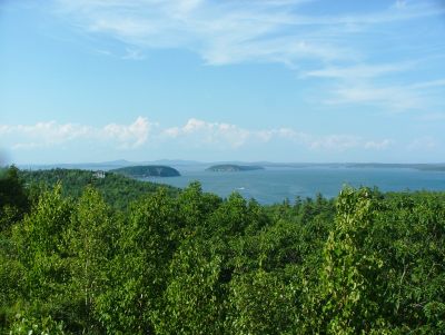
Several paths lead through the park, but we chose to
take on so-called Park Loop, a road that begins just
outside of Bar Harbor, and goes along the island's
east coast, and thence back to square one, hence the
name "loop".
We only saw the easternmost part of the island, but
there were enough to look at, not least sea, forest
and rocky shores.
Among the places where we stopped to photograph, was
Sand Beach, Thunder Hole, Otter Point and Otter Cove.
We saw no otters though and no seals in Seal Harbor.
The latter is one of the small villages that are
sprinkled across the island.
As we drove away we had to stop to watch and
photograph a raccoon who was out walking on the road.
It was not very big, so Dorte and I agreed that it
was probably a "puppy".
When
we had seen enough of it, we drove back north until
we came to a parking lot at the Bubble Pond, a small
lake.
Here we went for a walk to see the lake and its
surroundings.
It was quite beautiful, and we stood and enjoyed the
silence - until it was interrupted by shouting and
laughing from children up on the hillside.
Then we went on!
We completed the rest of the
loop, and then drove back to the hotel.
- Return to New
Enlgand and New York -
- Return to Travel Stories -