Towns, Mountains and Waterfalls
Thursday, as it had now become, I had set aside for sightseeing on a longer trip west (still in North Carolina though). Already at 8.30 I left the house in Ferguson and initially headed for Lenoir and from there south to Morganton. My plan was to take I-40, which I just reached in Morganton, west to somewhere in the neighborhood of Asheville, then head south on minor roads. On the way to Asheville, I considered whether I should take a detour and visit the town, which, with its population of just under 90,000, is the largest town in western North Carolina, but I gave up on that. At the small town of Clyde, where I-40 turns north toward the Tennessee border, I left the freeway and instead took US Route 74, which heads southwest and just passes through Franklin on its way to Tennessee (or rather; the road starts in Chattanooga in Tennessee and ends in Wrightsville Beach in North Carolina, but now I drove the opposite direction, and only for a short distance). Between Clyde and Franklin, the town passes the county seats of Waynesville (Haywood County) and Sylva (Jackson Country), but I didn't visit either county seat this time, mostly because I've visited them both before, but also to save time. Sylva, though has a neat old courthouse on top of a hill, although today it functions as a library, not a courthouse.

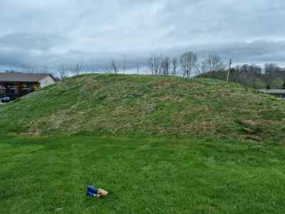
The Cherokee Mount in Franklin, Macon County. Before the establishm,ent of Franklin, this was the location of the Cherokee town of Nikwasi.
From Clyde to Franklin there are only around 45 miles, but since US 74 is quite winding on this stretch through the mountains, it still took about an hour and a half, even though the road is four-lane for this entire stretch. The only detour I took was to drive through Dillsboro, west of Sylva, but I don't really know why I did that, because I didn't stop in town, but just got back on US 74 and continued on my way. In Franklin I stopped at a gas station I have used on previous visits, and here I bought a cup of coffee and a sandwich (as I have also done on my previous visit). After that I crossed the main street where the tank is located and looked once more at the small mound that is there. The mound was originally a ceremonial mound in the Cherokee village of Nikwasi, and the tribe's council house stood on this mound. Here in Nikwasi, Alexander Cummings, a self-appointed emissary from the English king, in 1730 tried to persuade the Cherokee tribe to recognize that George II, as the king was called (but probably without a number), should have supremacy over the Cherokees. He succeeded in getting one village chief, Moytoy of Great Tellico, to let him (Cummings) proclaim him (Moytoy) "Emperor of the Cherokee", but he was recognized by very few members of the tribe, primarily from his own village, and the rest of the tribe continued their lives as if nothing had happened, and actually nothing had. But today, Moytoy is considered the tribe's first principal chief, even though only a few tribe members thought of him as anything of the kind. But when you take an interest in the Cherokee, as I do, it is interesting to see memories of the time when the tribe controlled an area the size of modern-day Germany.
When I had eaten my sandwich and drunk my coffee, I found a parking lot in downtown, which is not very big (downtown that is, not the parking lot), but which I had never seen before. On previous visits, I had only been interested in the mound and the Little Tennessee River, which meets the Cullasaja River in the southeast part of the town. After seeing enough of this part of town, which is similar to the downtown of many other small towns in the area, and shooting some video for my Glocal Explorer channel on YouTube, I got back in the car and headed for Highlands, the only other settlement in Macon County, except for Franklin, the county seat, which is classified as a town. Besides these two towna, there are only so-called unincorporated communities in this county. On the other hand, there are fifteen of them, one of which has the interesting name Otto! From Franklin to Highlands, you have to climb a good 1,900 feet from the 1,960 feet elevation of Franklin, to the 4,000 feet which is Highlands' elevation above sea level. Between the two towns, you drive on US Route 64, which is a fairly long highway. It begins at Nags Head in North Carolina and ends more than 2,300 miles further west at Teec Nos Pos in Arizona. I didn't drive that far though. Between Franklin and Highlands there are only 20 miles; on the other hand, the main road on this stretch is two-lane and very winding because it follows the course of the Cullasaja River.

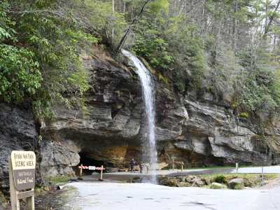
Bridal Veil Falls on a trbutary to Cullasaja River.
On the way between Franklin and Highlands, the road passes four waterfalls, and I stopped at a few of them, Bust-Your-Butt Falls, which is actually called Quarry Falls, but has been nicknamed because it is popular (especially with children) to use the lower part of the waterfall as a water slide and also at Bridal Veil Falls I made a stop. There was much more water in the rivers than on my previous visit, which was in July 2019, and this made for some good photos, not least at Bridal Veil Falls, which is a small waterfall on a tributary of the Cullasaja River, but still next to US 64, Here you can walk behind the waterfall and photograph through this, so I did. When I reached Highlands I found a place to park the car, although it was hard to find an empty space. The town is a tourist magnet, not least in winter, when it is known as a ski resort, but there were also many people in April, perhaps on the occasion of Easter, even though Maundy Thursday is not a public holiday in the USA as it is in Denmark. But there were a lot of cars there, and a lot of people on main street, but I got to walk up and down the street and got to take some pictures and more video, which will be combined into a single video from this part of the state, which will be posted on YouTube (it already is and can be found with this link).
From Highlands, my plan was to continue on US 64 to
Rutherfordton in Rutherford County, so I left town again in an easterly
direction. Also, this stretch of US 64 is relatively winding, and along the way
you pass another county seat, Brevard in Transylvania County (if you want to
know more about all these counties in the western part of North Carolina, I can
recommend my book, "Land of Friendliness and Beauty - a Dane's guide to western
North Carolina", which can be bought in well-stocked online bookstores, and you
can probably also get your local bookstore to order it home). Along the way I of
course passed through several low mountain ranges, but gradually it flattened
out somewhat and became hilly country, where I drove through what most of all
looked like a Danish summer cottage area. After passing Brevard, I happened to
look at my watch and saw that if I wanted to visit Rutherfordton it would be
very late before I was back in Ferguson, so by the time I reached Interstate
Highway 26 somewhere south of Hendersonville, I chose to take this north to
where it met I-40 south of Asheville. On the way north I ran into a couple of
long tailbacks where the traffic had almost come to a standstill, but it turned
out to be just the usual evening rush hour. The first one I met around the local
regional airport. The next tailback was when I entered the southern suburbs of
Asheville, and it continued but to a lesser extent when I got to I-40 but
eventually it thinned out and I was able to speed up.
On the way from Lenoir to Ferguson, I stopped at a Food Lion and bought some
food that I could heat up in the microwave so I wouldn't have to leave again for
dinner. I was back in Ferguson around 7 pm, so it had been quite a long day. In
total I had driven about 375 miles, which would turn out to be the longest
distance driven in a single day on the trip - but I had seen a lot so it was a
really good road trip day. Once at home, I warmed up the food I had bought, and
when I had consumed it, I started to do my laundry, while I sat on the small
veranda and drank my evening coffee. In addition, I was able to check mail and
the world situation via my E-subscription to my Danish newspaper.