Cacti, cowboys and indians
When we left Las Vegas we drove south to Hoover Dam.
Here we chose to just look at the dam from a view
point so we would not spend time looking for a more
permanent parking space as we had quite a distance
to go that day.
From the dam we continued south to Kingman, Arizona.
Here
 we
ate a light meal at a local restaurant and got a
re-supply of water for our cooler, and then we drove
along famous U.S.
Route 66 to
Seligman, Arizona. When
Dorte and I drove the same stretch in 2006, we saw
rain clouds in the distance, but not any actual
rain.
Exactly the same thing happened this time.
Rain clouds in the distance, but no rain, where we
drove.
We stopped a few times to take pictures, including the Grand Canyon Caverns
with its Historic Route 66 sign, where we took
pictures of the sign and our car.
we
ate a light meal at a local restaurant and got a
re-supply of water for our cooler, and then we drove
along famous U.S.
Route 66 to
Seligman, Arizona. When
Dorte and I drove the same stretch in 2006, we saw
rain clouds in the distance, but not any actual
rain.
Exactly the same thing happened this time.
Rain clouds in the distance, but no rain, where we
drove.
We stopped a few times to take pictures, including the Grand Canyon Caverns
with its Historic Route 66 sign, where we took
pictures of the sign and our car.
From Kingman Route 66 leads in an arc north and then
south again.
In the northernt part you drive into the Hualapai
Indian Reservation, where the road goes through the
reservation capital, Peach Springs, before it goes
south.
The tribe is relatively small with only about 1,300 members, but our "visit"
here was the beginning of a series of visits or at
least passing through Indian reservations in Arizona
and the neighboring states.
When we got to Seligman four years earlier, we drove
directly onto the
freeway
and continued to Williams, but this time we made a
wrong turn, so we ended up in Seligman, which
is one of the towns along Route 66, that
has best preserved the style of 50s.
So our mistake proved to be an advantage.
Eventually we had to enter the I-40, which we were
to follow a few miles east.
Here history repeated itself one again. When
Dorte and I drove here in 2006, the rain that we had
seen in the distance hit us and we had to
use the wipers once, then the rain was over.
This time however it rained so little that although
we got rain drops on the windshield, it was not
necessary to wipe. Strange
is that I have now been six times in the U.S., and
on five of the visits, I've driven on I-40.
And we got to drive it a few more times later on the tour.
When we reached the U.S.
89, we turned south.
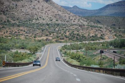
Route 89 goes through Prescott National Forest and
is all the way to Phoenix classified as "scenic
route", and it is indeed.
We followed the road which in places is fairly
narrow down to the town of Prescott.
From there we took Arizona Route 69, which is an
even smaller road, east to Interstate Highway 17,
which we would follow to Phoenix.
We could have stayed at Route 89, but it would have
required us to drive through the city center.
 Our
initial plan was to stay overnight in the town of
Black Canyon City, but when we arrived there, it was
still relatively early in the afternoon, so we
decided to continue south.
In Phoenix I-17 ends and we switched to I-10, which
continued south towards Tucson.
As we approached the town, we began to look for a
hotel.
We had traveled far and was getting a little bit
tired.
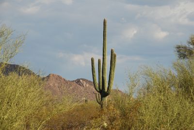
We would however like to take this opportunity to
see the western part of Saguaro National Park, known
for its large cacti.
Already on the way down the highway we had seen some
cacti along the road, but they were not big enough
for us!
On our map it looked like we had to leave the
highway at the town of Red Rock, so we did.
This led us into a very exciting area of cattle
farms and other agricultural landscapes, and we came
very close to the Tohono O'Odham reservation, home
to an Indian tribe of the same name, but no National
Park.
We therefore returned to the freeway and continued
south to the town of Cortaro, where we finally found
a sign pointing to the national park.
It turned out that the park was about 15 miles from
the highway, and many parts of the road there was
very narrow.
When we reached the park's Visitor Center, it had
closed at 5 PM, and it was 6 PM, when we got there.
We decided to drive around the park roads anyway and
look at the cacti. There were many different kinds
of cacti, not least the large Saguaro, which has
given the park it's name.
We took a lot of pictures of cacti, which will also appear on
Pictures from Arizona
some day when I get to the new pictures from that
state.
Our
initial plan was to stay overnight in the town of
Black Canyon City, but when we arrived there, it was
still relatively early in the afternoon, so we
decided to continue south.
In Phoenix I-17 ends and we switched to I-10, which
continued south towards Tucson.
As we approached the town, we began to look for a
hotel.
We had traveled far and was getting a little bit
tired.
We would however like to take this opportunity to
see the western part of Saguaro National Park, known
for its large cacti.
Already on the way down the highway we had seen some
cacti along the road, but they were not big enough
for us!
On our map it looked like we had to leave the
highway at the town of Red Rock, so we did.
This led us into a very exciting area of cattle
farms and other agricultural landscapes, and we came
very close to the Tohono O'Odham reservation, home
to an Indian tribe of the same name, but no National
Park.
We therefore returned to the freeway and continued
south to the town of Cortaro, where we finally found
a sign pointing to the national park.
It turned out that the park was about 15 miles from
the highway, and many parts of the road there was
very narrow.
When we reached the park's Visitor Center, it had
closed at 5 PM, and it was 6 PM, when we got there.
We decided to drive around the park roads anyway and
look at the cacti. There were many different kinds
of cacti, not least the large Saguaro, which has
given the park it's name.
We took a lot of pictures of cacti, which will also appear on
Pictures from Arizona
some day when I get to the new pictures from that
state.
After our visit to the park we found a hotel on the east side of Tucson, after 525 miles of driving and a lot of impressions.
 After
our overnight stay , we
drove back to the
freeway (I-10) an took
it to Benson, about 40
miles to the southeast.
From there we drove
south to Tombstone,
where we were already at
10 AM.
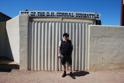
We found an empty
parking lot on Fremont
Street just opposite the
OK Corral - one of the
reasons that we had come
to town. Next to
the OK Corral was
Camillus Fly's photo
studio, just as on the
26th of
October 1881, when the Earp brothers and Doc Holiday
met the Clanton and
McLaury brothers and
Billy Claiborne in the
West's most famous
gunfight.
After
our overnight stay , we
drove back to the
freeway (I-10) an took
it to Benson, about 40
miles to the southeast.
From there we drove
south to Tombstone,
where we were already at
10 AM.
We found an empty
parking lot on Fremont
Street just opposite the
OK Corral - one of the
reasons that we had come
to town. Next to
the OK Corral was
Camillus Fly's photo
studio, just as on the
26th of
October 1881, when the Earp brothers and Doc Holiday
met the Clanton and
McLaury brothers and
Billy Claiborne in the
West's most famous
gunfight.Actually the duel did not take place in the OK Corral but in an empty lot, right next to the photo studio. The actual OK Corral was a bit further down the street. The duel ended with the two McLaury brothers and Billy Clanton getting killed while Ike Clanton and Billy Claiborne escaped unharmed. To tell the whole story that led up to the duel would fill several pages, enough is to say that the famous duel lasted only about 30 seconds. The three killed are buried in the city's old cemetery, which we later visited.
We walked from Fremont Street to Allen Street, the city's old main street, which is still kept in the old style with wooden sidewalks and false facades. Here we looked at the many shops etc. We didn't visit the site of the shootout, as the first re-enactment performance would taker place at 2PM, and we didn't want to wait that long. Since there really was no more to look at, we headed for Boot Hill, the city's ancient cemetery. Here we saw the many graves, and not least their inscriptions. Some are fairly laconic: "John Martin, killed 1882", "Dan Down Hanged 1884 or" Van Houten, 1879, Murdered "and so on. A marker on the duelist's tomb reads "Billy Clanton, Tom McLaury, Frank McLaury. Murdured on the streets of Tombstone, 1881. "(Note: The spelling error actually occurs on the tombstone). There are also more poetic writings such as the famous, that are often shown in pictures from the cemetery: "Here lies Lester Moore. Four Slugs from a 44. No Les, no more" or my own favorite: "Here lies George Johnson, hanged by mistake in 1882. He was right, we was wrong, but we strung him up, and now he's gone."
After visiting the cemetery, we continued further south to Bisbee. Here we saw the very large open copper mine. Then we continued further south to Douglas at the Mexican border. We did not go into Mexico but simply took some pictures of the crossing before we drove north again to I-10. This was the southernmost we got on this trip. As we drove north again, we passed a Border Patrol control station about 15 to 20 miles north of Douglas. Here we had to show our passports so they could see we were not illegal immigrants from Mexico. They did not look quite convinced though, when we claimed to come from
 Denmark,
not Mexico, but we were
allowed to go on. We
continued north through
small towns with names
like McNeal and Elfrida.
The last town before we
reached the highway was
called Sunsite, and here
there was an exit to
Cochise Stronghold.
We considered a visit,
but since we still had
quite away to go before
calling it a day, we
decided not to. After a
few miles on the
interstate, we turned
north to the San Carlos
Indian Reservation.
The reservation
is the
home of remnants of
several Apache groups.
Among the groups that
live in the reservation
is the Arivaipa, the
Pinal and the San Carlos
Apaches.
Around
9,000 Native Americans
live on the reservation,
and they are some of the
poorest Native Americans
in the U.S. of A.
Nearly 60% of the
population live below
the official poverty
line in the U.S. and an
average household is
earning less than $
14,000 per year.
However, there is opened
a casino on his
reservation, which
provides some income
from tourists.
It is the tenth largest
reservation in the U.S.,
but most of it is
desert, mountains and
pine forests.
Denmark,
not Mexico, but we were
allowed to go on. We
continued north through
small towns with names
like McNeal and Elfrida.
The last town before we
reached the highway was
called Sunsite, and here
there was an exit to
Cochise Stronghold.
We considered a visit,
but since we still had
quite away to go before
calling it a day, we
decided not to. After a
few miles on the
interstate, we turned
north to the San Carlos
Indian Reservation.
The reservation
is the
home of remnants of
several Apache groups.
Among the groups that
live in the reservation
is the Arivaipa, the
Pinal and the San Carlos
Apaches.
Around
9,000 Native Americans
live on the reservation,
and they are some of the
poorest Native Americans
in the U.S. of A.
Nearly 60% of the
population live below
the official poverty
line in the U.S. and an
average household is
earning less than $
14,000 per year.
However, there is opened
a casino on his
reservation, which
provides some income
from tourists.
It is the tenth largest
reservation in the U.S.,
but most of it is
desert, mountains and
pine forests.
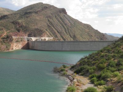
At the town of Globe, we left the reservation again and then we started looking for a place to stay. However, there was nothing that appealed to us in Globe, so we continued on northwest and later north east along another scenic route through the mountains, The Sierra Ancha. We passed an artificial lake, Lake Roosevelt, and here we thought that we might find a hotel, but no. We passed several campsites and cabins, but no hotels. In stead we enjoyed the drive along the lake and later along Tonto River. It was on this stretch that our board computer started telling us that it was time change the oil on the car. As we could not really do anything, we contiued to Payson, where we found a hotel and got a room. When we arrived, the lady at the reception desk asked us what on earth we were doing in Payson, Arizona? The city, located 4,000 feet above sea level is know to be situated almost exactly in the center of the state of Arizona. And I could tell her, that we were just passing through.