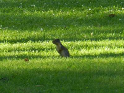
Out for a hunt
After the whale tour on
Sunday, it was time to leave Anacortes and head southeast. We drove from Fidalgo
Island to the mainland, and south on I-5. When we reached U.S.
Route 2, we followed that east through the Cascade
Range. Not as fast as the highway, but much prettier. On the way up the
mountains we passed small towns with interesting names like Sultan,
Start Up, Gold Bar, Index, Grotto and Skynomish.
In Stevens Pass, we reached the highest point on the trip through the mountains
in 4,056 feet. Then it went downhill on the east side of the Cascade Range. For
some reason, the towns don't have nearly as interesting names on the east side
of the pass. If these names are not interesting (maybe with the exception of
Cashmere, Monitor and Sunnyslope ) at least one of the towns is
interesting, namely Leavenworth. The whole town (or at least most of it) is
constructed as a Bavarian village with houses and hotels and more in Bavarian
style. Even Starbucks is in a
Bavarian chalet. Inspired by the "Danish town" Solvang in California, a project
to boost the city's tourism by turning it into a Bavarian village began in 1962.
From Leavenwoth we continued down through the mountains to Wenatchee in the
foothills, where we found a Walmart and got ice and water for the cool box.
 From
Wenatchee, we headed south on rather small roads to I-90, which we then followed
east. We wanted to get as far as possible thaty day, so from here on, we decided,
the interstate would be faster after all. We took the highway northeast to
Spokane, the largest city in eastern Washington and continued on I-90 for the
rest of the day. From Spokane there is only about 12 miles to the Idaho border
which we passed almost without us noticing. State lines in the United States
typically just have a sign that says "Welcome to Idaho" or the like, and
it was just what was on the sign post here. After crossing the border, we
continued along I-90 towards Wallace, where we intended to stay overnight. When
we got to this old mining town, I had been entertaining Tina about the area's
silver mining history, the mine accident in Kellog and much more, and Tim had
mentioned his dear bordellol museum in Wallace. Tina was not interested
neither in mines nor bordellos though and even the manhole cover that is the
named center of the universe did not awake any excitement, so we agreed to
continue to Missoula in Montana.
From
Wenatchee, we headed south on rather small roads to I-90, which we then followed
east. We wanted to get as far as possible thaty day, so from here on, we decided,
the interstate would be faster after all. We took the highway northeast to
Spokane, the largest city in eastern Washington and continued on I-90 for the
rest of the day. From Spokane there is only about 12 miles to the Idaho border
which we passed almost without us noticing. State lines in the United States
typically just have a sign that says "Welcome to Idaho" or the like, and
it was just what was on the sign post here. After crossing the border, we
continued along I-90 towards Wallace, where we intended to stay overnight. When
we got to this old mining town, I had been entertaining Tina about the area's
silver mining history, the mine accident in Kellog and much more, and Tim had
mentioned his dear bordellol museum in Wallace. Tina was not interested
neither in mines nor bordellos though and even the manhole cover that is the
named center of the universe did not awake any excitement, so we agreed to
continue to Missoula in Montana.
I-90 passes through several mountain ranges on it's way east, and
on the Idaho-Montana border it passes through Bitterroot Range, which is a spur
of the Rocky Mountains. The highest point of this part of the trip was reached
in Lookout Pass in 4,710 feet. The state line is crossed right at the top of the
pass. It was on the eastern descend from the pass that Tim and I last year
counted 13 times, where the highway crossed the Clark Fork River. This time we
continued a bit further on the interstate and managed to cross the river a total
of 20 times before we got to Missoula, where we found a hotel and had something
to eat - in that order. The 560+ miles from Anacortes to Missoula would prove to
be longest drive on the vacation.
On to Yellowstone National Park
The long drive the day
before, meant that we wouldn't have to drive quite so far today to get to
Gardiner, Montana at the northern entrance to Yellowstone National Park, which
was out next goal. We chose to drive to Gardiner through Idaho and Wyoming,
which may sound like a detour as we were already in Montana, and it is slightly
longer than the direct route, but not that much - and the trip is more
interesting. We therefore continued east on I-90 the next morning, but only for
around 160 miles. Then we turned south on minor roads through Madison Valley (where
Madison River runs). The first part of the route lead through narrow valleys,
where there were virtually only room for the river and the road, but as we got
further south, the valley got wider and there was also room for ranches along
the river. Many of these offered fly fishing and some even B&B, and in some
places you could also do some horseback riding, but we were not interested in
any of that - at least not for the time being. Tina wanted to go riding, but has
already booked a horseback ride in Utah. All the way to the south the road
ascended, but without us really noticing it. Missoula is located some 3,000 feet
above sea level, while Yellowstone NP is located more than 6,500 feet above sea
level, and in some places it reaches in excess of 8,000 feet.
As we approached Yellowstone, we passed Hebgen Lake, a lake on
the Madison River made by the Hebgen Dam. The area is known for a violent
earthquake that took place here in 1959. The earthquake occurred along a fault
actually called Hebgen Lake Fault. It measured 7.5 on the Richter scale, a very
powerful earthquake that cost 28 lives, although the area is relatively
uninhabited. In addition, the quake created a new lake, Quake Lake, which we
also passed Along the lake there were several rest areas where there were
sign posts, that explained different things about the earthquake, but we did not
stop at any of these. Instead we continued to the town of West Yellowstone in
Idaho just outside the park, where we switched driver for the second time that
day. I had to go behind the wheel, because when we entered the park, I was
supposed to pay the entrance fee. Then we continued to the park's west entrance
where I bought an annual pass for all U.S. national parks for $ 80. At home I
had figured out that with the national parks and national monuments, we had made
plans to visit, it would be a good deal. Shortly after the entrance you leave
Idaho and enters Wyoming.
Right after we had entered Wyomingn, we made a stop next to
Madison River, where we ate a sandwich, home made from the contents of the
cool box. From there Tim took the steering wheel for the first time that day. He
drove us from the rest area into the "main road that as a figure eight meanders
through the park's central parts. The road is called Grand Loop Road, and we
drove a lot on that in the next few days. Part of the road is an unnumbered part
of U.S. Highway 89, which we have often used, and which we would get to use also
at later occasions this time. The first stop we made was at Gibbon Falls, a
small waterfall on the Gibbon River that has its entire run inside the national
park. Here we went for a short walk along the edge on a paved path, and took
some pictures of the river and the waterfall.
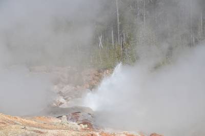 Next
stop was Norris Geyser Basin, one of the national park's many geyser areas, and
one of the more special. The area is on the edge of Yellowstone's caldera, the
remains of the huge volcanic eruption that occurred 640,000 years ago. Moreover,
two faults, Hebgen Lake fault and Norris-Mammoth Fault meets in this area. The
many earthquakes, this causes (more than 400 a day, most of them so small that
only a few people if any notice them), lead to frequent alterations in the
hot springs and geysers, that the area has plenty of. The springs are some of
the hottest in Yellowstone, and many of them contains acidic water, not alkaline
as most of Yellowstones springs does. The temperature and the acidic water are
ther reason that other bacteria thrives here than in most other places in the
park, which helps to provide other colors of springs than you see elsewhere. In
Norris, we stayed for a while and went for a walk in one of the basins three
separatge areas, called Back Basin. Here we passed among others the world's
tallest geyser (when it bothers to erupt that is), Steamboat Geyser. We saw a
lot of small eruptions that reached up to 15 feet or so, but the last major
eruption took place in 2005, and no major eruptions occurred thise time either.
It must be an impressive sight though to see the geyser send 200 degrees hot
water 300 feet up in the air. A park ranger was explaining the geyser, but Tim
and Tina would rather like to continue our walk (it was a very hot afternoon,
probably about 100 degrees in the shade when you could find any) and we only had
brought half a liter of water each.
Next
stop was Norris Geyser Basin, one of the national park's many geyser areas, and
one of the more special. The area is on the edge of Yellowstone's caldera, the
remains of the huge volcanic eruption that occurred 640,000 years ago. Moreover,
two faults, Hebgen Lake fault and Norris-Mammoth Fault meets in this area. The
many earthquakes, this causes (more than 400 a day, most of them so small that
only a few people if any notice them), lead to frequent alterations in the
hot springs and geysers, that the area has plenty of. The springs are some of
the hottest in Yellowstone, and many of them contains acidic water, not alkaline
as most of Yellowstones springs does. The temperature and the acidic water are
ther reason that other bacteria thrives here than in most other places in the
park, which helps to provide other colors of springs than you see elsewhere. In
Norris, we stayed for a while and went for a walk in one of the basins three
separatge areas, called Back Basin. Here we passed among others the world's
tallest geyser (when it bothers to erupt that is), Steamboat Geyser. We saw a
lot of small eruptions that reached up to 15 feet or so, but the last major
eruption took place in 2005, and no major eruptions occurred thise time either.
It must be an impressive sight though to see the geyser send 200 degrees hot
water 300 feet up in the air. A park ranger was explaining the geyser, but Tim
and Tina would rather like to continue our walk (it was a very hot afternoon,
probably about 100 degrees in the shade when you could find any) and we only had
brought half a liter of water each.
We continued the tour and passed Echinus Geyser, the world's
largest acidic geyser, which also didn't erupt and passed several other
geysers and especially hot springs and mud holes. Towards the end of the walk we
could look out over one of the other areas, Porcelain Basin, but we agreed that
we did not have the energy to walk any further. The hike had taken us about one
and a halft hour, so we were hot when we got to the overlook and we preferred to
return to the air conditioning and some cold water from the cool box. We
continued north along Grand Loop Road passed places like Roaring Mountain and
Obsidian Cliff. When we got up to the northern part of the Grand Loop, we drove
to Mammoth Hot Springs, Upper Terraces, where you can also go for a walk, but we
all agreed only to drive around the area in the car. This proved to be enough to
get a look at the many limestone terraces which water from the underground have
formed and that are not found elsewhere in the national park. After the round
trip, we continued north through Mammoth Hot Springs Village, where the first
fort was built after Yellowstone had become a national park in 1872, when it was
the military that was responsible for taking care of and protecting the park.
Later that responsibility passed to the National Park Services and their park
rangers. Today the old barracks buildings are used as accommodation for
most of the volunteers who work in this part of the park.
From the village we continued towards the park's northern entrance and Gardiner
Montana, where we were to stay for the next couple of days. Along the way, at a
place where the road was very narrow, a lot of cars were parked at the roadside.
Such crowding in Yellowstone NP usually almost always mean that someone has seen
or believe that they have seen one or another type of animal. Since we could not
pass, we stopped too. It turned out that someone thought they had seen mountain
goats on a nearby rocky slope. The park ranger present could not see anything
though, and we couldn't either. So when the road got passable again, we squeezed
ourselves past and continued out of the park to our hotel where we got ourselves
accommodated.
All God's Creatures, Great and Small
The headline here is actually the title of an old British televison series about a veterinarian in Yorkshire, but I found it fitting for this next chapter.
Right next to the hotel
in Gardiner is the Yellowstone Mine Restaurant, where Dorte and I had dinner
with Jens and Annette in 2006, and where Tim and I had eaten in 2010. When it
got a little past 6, we went here again and the food was certainly as good as at
previous visits. After dinner we went back to the car that was parked at the
hotel. It was in this part of the country, that Tim and I in 2010 was stung by
so many mosquitoes that we almost had to have a blood transfusion, so this time
we took our precautions before we headed out into the countryside. We sprayed
outselves with insect repellant in large quantities to keep mosquitoes as well
as other biting or stinging insects away. It must have worked rather well
because we actually didn't meet a single mosquito, except for Tina who got three
mosquito bites. I think that we may have put on so much repellant that all other
mosquitoes had left northwestern Wyoming and southern Montana.
 Our
plan was to drive back to Mammoth Hot Springs Village and from there along the
northeastern part of Grand Loop Road to a crossroads called Tower Junction. Here
we would turn east on the road that leads to the park's northeast entrance. This
road leads through the Lamar Valley, which is called North America's Serengeti
because of the abundant wildlife in the valley. In 2010, Tim and I, besides the
aforementioned mosquitoes saw elks and especially bison in quantity, some of
which walked around on the road and stopped the traffic. One bull in particular
stopped traffic for almost 30 minutes by just standing in the middle of the road.
We also saw a bear on a distant hillside in the semi-darkness but so far away
that all you can spot in our pictures is a dark dot, that might as well be a
pixel error. But now it was as Tina's turn to see animals. And she must have had
a good impact on the wildlife, because we got to see animals as we had not seen
them in the wild before.
Our
plan was to drive back to Mammoth Hot Springs Village and from there along the
northeastern part of Grand Loop Road to a crossroads called Tower Junction. Here
we would turn east on the road that leads to the park's northeast entrance. This
road leads through the Lamar Valley, which is called North America's Serengeti
because of the abundant wildlife in the valley. In 2010, Tim and I, besides the
aforementioned mosquitoes saw elks and especially bison in quantity, some of
which walked around on the road and stopped the traffic. One bull in particular
stopped traffic for almost 30 minutes by just standing in the middle of the road.
We also saw a bear on a distant hillside in the semi-darkness but so far away
that all you can spot in our pictures is a dark dot, that might as well be a
pixel error. But now it was as Tina's turn to see animals. And she must have had
a good impact on the wildlife, because we got to see animals as we had not seen
them in the wild before.
The first animal we saw, apart from birds and mule deer in
Mammoth Hot Springs Village, was a beaver that crossed the road in front of the
car not far from Tower Junction, but unfortunately it was impossible to stop and
take pictures before it had disappeared into the trees along the road side. A
little further up the valley we met the first bisons albeit they were at some
distance. Of cause the dream of every tourist is to see larger wildlife like
bison, wolf and grizzly, but the only predator I have come across so far, was
the bear on the distant hill in 2010, and a mangy coyote in 2006 in Hayden
Valley. That would change in a few minutes though.
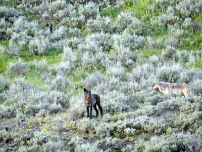
After a few more miles of driving east, we could see a lot of
cars at the roadside ahead, so we were aware that there might be something
interesting to see, and when we arrived so we saw a small herd of bison very
close to the road. It turned out, however, that it was not what made everybody
stare, but the two wolves that crept around in the low vegetation a short
distance from the bison herd. Later it turned out that there were actually four
wolves in the bushes and two more on a hillside above the bisons. One of the
wolves suddenly started howling, which we could not quite understand at that
time since we thought that it would warn of the bisons, but I later read that
wolves actually howls on the hunt to signal the rest of the pcak that prey is
near, and it did actually made the two wolves on the hillside move in direction
of the bisons. So maybe the howl just meant: "We are in place. Go get them!".
So not only did we see wolves, but we saw something as rare as wolves on the
hunt. We were told by someone that normally you only experiences hunting wolves
so close to the road during wintertime. They stayed at the bison herd very long,
trying maybe to separate a calf from the other bisons, but it was to no avail.
The large bison bulls continued to position themselves between wolves and calves,
and such a bison bull is large, and when there are 10 of them, even six wolves
was not enough to succeed. Eventually the wolves gave up, called it a day and
disappeared up the slope and we could also move on - a great experience richer.
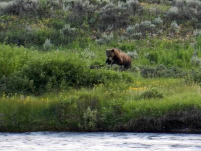 We
did not go very far though, for only about a half mile later we were stopped by
a park ranger who was about to put up a sign telling not to stop, leave the car
or otherwise walk for the next mile of road. He was wearing a vest with the text
Yellowstone Wolf Project, so we figured that there were more wolves, but
that was not the case. We were allowed to stay a while where we already were and
could now see that a little ahead, in the tall grass about 150 to 250 feet from
the road a grizzly bear was feeding on a dead bison. This view we enjoyed for
some time before we continued around a mile, where we turned around and parked
the car again. We were on the right side of the sign and could leave the car as
many others had already done. We were now rather far from the bear, but could
still see it, and also got some reasonable pictures of it, although it was
almost a mile away and darkness was beginning to settle. Finally the bear layed
down and became largely invisible behind the bison, and then we decided to
return to the hotel. While we stared at the grizzly a black bear came out of the
woods on the opposite side of the Lamar river. It was probably two or three
miles away and the pictures only shows a vague silhouette of the bear.
We
did not go very far though, for only about a half mile later we were stopped by
a park ranger who was about to put up a sign telling not to stop, leave the car
or otherwise walk for the next mile of road. He was wearing a vest with the text
Yellowstone Wolf Project, so we figured that there were more wolves, but
that was not the case. We were allowed to stay a while where we already were and
could now see that a little ahead, in the tall grass about 150 to 250 feet from
the road a grizzly bear was feeding on a dead bison. This view we enjoyed for
some time before we continued around a mile, where we turned around and parked
the car again. We were on the right side of the sign and could leave the car as
many others had already done. We were now rather far from the bear, but could
still see it, and also got some reasonable pictures of it, although it was
almost a mile away and darkness was beginning to settle. Finally the bear layed
down and became largely invisible behind the bison, and then we decided to
return to the hotel. While we stared at the grizzly a black bear came out of the
woods on the opposite side of the Lamar river. It was probably two or three
miles away and the pictures only shows a vague silhouette of the bear.
By now it was almost completely dark, so we decided to head back. On the way we
met only a few elks and when it was completely dark a moose with a calf crossed
the road some distance ahead of us, but unfortunately it was now too dark to
photograph at all, so we didn't get any pictures of the moose. We went back to
the hotel, some amazing experiences richer; experiences which actually was worth
the trip whole trip to USA and we agreed that it would be difficult to surpass
this experience, but we came close a few times. I will get back to that in
future articles.