A sunny day in Tennessee (and a couple of murders)
From home I had planned Thursday to be the day when I would visit Tennessee. It would also be the day with the longest driving distance except for thr last drive from Lenoir to Dulles International. On this cloudy and rainy Thursay morning I had ordered scrambled eggs and sausage for breakfast, and it was much lighter than the pancake I had the previous day. Breakfast was ready at 7.30 and I left Irish Rose around 8.15.
My orginal plan had been to visit Davy Crockett Birthplace State Historic Park southwest of Johnson City, and that was still the plan, but after my visit to Morganton, I had decided to pay a visit to Kona, the small settlement, where Frankie Silver killed her husband. I would also like to visit Pandora, another small settlement, where Tom Dooley was arrested after the murder of Laura Foster. I had been in Davy Crockett Birthplace Park once before in 2000, but at that time it was raining heavily and we were a bit worried, because we had lost track of my in-laws. More about this in the article How the Grandparents disappeared on the 2000 travel page. They arrived to the park half an hour after us, but we never found out where they had been for the 90 minutes we didn't have track on them and it was in the days before cell phones became popular. Anyway, my plans was Kona, Crockett and Pandora.
First murder of the day
When I left Irish Rose I had set my gps to locate Kona, which is no longer village, but Kona Road in Bakersville was in the old place, so I settled for that. The gps led me in direction of Morganton once more, but just before town it wanted me to turn west, and so I did. I might have taken a shorter route through the mountains, but I didn't. If I had, it would probablly have spared me a lot of frustration on Friday. And if I had taken NC 126 out of Morganton I would have passed the place, where Frankie Silver most likely is buried, but I didn't either. Instead I headed west on I-40 for about 20 miles. This added some trucks to my list though, so it wasn't completely wasted. Later I turned north on US 226 and later US 221, to a small town called Spruce Pine.
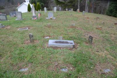
Charlie Silvers grave(s) in Kona
In Spruce Pine I left the highway and instead took a very narrow road, called State Route 80. I later discovered, that this was where Tim and I "got lost" after a detour en route from Asheville to Blowing Rock in 2012, see the article Three days in Dooley-country on the 2012 travel page. NC 80 took me all the way to Kona, so Tim and I must have passed the village in 2012 without me remembering, but at that time we didn't know it was interesting. Today Kona is a small settlement with a few houses, two churches and 3 or 4 roads, among these Kona Road and Old Kona Road. My first stop though was at Kona Baptist Church. It was not open, but the cemetery was, and that was what I was interested in. The cemetery is called The Silver Cemetery, because it originated as family cemetery for the Silver family, and still Silver is the dominant name on the gravestones.
I located Charles "Charlie" Silvers grave, which is rather special. At the top of the grave is a rather recent stone, with the text "Charles Silver, Dec. 3 1812 - Dec. 22 1831". Next to it are three much older stones and at the foot of the grave are three recent stones with the inscription CS on each of them. Why now the three stones? Well Frankie Silver didn't just kill her husband with an axe, she cut the corpse to pieces, and not all pieces were discovered at the same time. When new parts where discovered, the family didn't want to open the grave, so they simply dug a new one next to it, and that happened twice, therefore the three stones. I told you it was a Tour de Macabre. The small cabin where Charlie and Frankie Silver lived was in a valley below the church, but it is long gone. The house where Charlie grew up with his parents do still exist on Old Kona Road or maybe Gordon Silver Road (it's right between the two roads, so I don't know the actual address). That was my next stop and I got a few pictures of the old house.
Then I told my gps to take me to Davy Crockett's birthplace.
The sun broke through
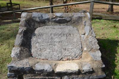
Davy Crockett birthplace memorial.
The gps had me continue north on NC 80 for around six miles. Then I was met NC 226A. I followed that to the Tennessee border, where it changed number to Tennessee Route 107. I didn't know that at the time and I wasn't sure I had passed the state line, so when I stopped to get some gas for the car I asked if I was in Tennessee, which was confirmed. At this time the sun was coming through the clouds, and the temperature had gone up from 68 to 75. In a town called Unicoi, the gps told me to turn left, so I did, and soon after I was on I-26. After only a few miles I left the interstate again only to once more find myself on Tennessee Route 107, on which I should stay for the rest of the way. At this time the sun was shining from an almost clear blue sky and I could really enjoy the beautiful fall colors along the way.
When I parked my car in the state park, the temperature had gone up to a very nice 84. I visited the replica of Davy Crocketts birthplace home, and took a walk along Nolichucky River. I studied all the information signs, and had a long talk with a park ranger about the area, and what I was doing there :-). Then I visited the information center before I headed out again.
As Pandora is so small that my gps doesn't know it, I set it to guide me to Trade on the Tennessee/North Carolina border as Pandora is only a little away from Trade. Then I left the place heading northeast. As I had nothing to see along the way, or so I thought, I just followed the instructions from the gps. In the town of Limestone I changed to US 321, a road well known from the previous days in North Carolina. Continuing northeast on 321, I wasn't actually aware of where I was. So when I passed through the outskirts of a larger city, I didn't know what city it was. When I passed East Tennessee State University I recognized the town as Johnson City though. I didn't enter town but continued on 321. Along the way I had passed through Jonesborough, but didn't think much about it at the time. I'lle get back to Jonesborugh below. In Johnson City I got a picture of a road sign reminding of the time (1784 - 1788) when this part of ther country was an autonomous state, known as State of Franklin - and that was the name of the road.
Cherokees and another murder
The next town I reached was Elizabethton. This town was home of the first independent American government west of the original 13 colonies, but that wasn't why I found it interesting. It was also in this town, that the so-called Transylvania Land Puchase took place in 1775. In this purchase members of the Cherokee Tribe sold as large tract of land in what today is northern Tennessee and southern Kentucky to a private company, Transylvania Land Company owned by one Richard Henderson. The sale was illegal as according to British Law no private individual or company could buy land from native americans, and also according to Cherokee Law as no member of the tribe, be he chief or otherwise could sell Cherokee Land, to white people. The purchase became a fact though, and was a major reason for the The Chickamauga Wars between white colonists and part of the Cherokee tribe, known as the Chickamaugas. This war lasted 18 years from 1776 to 1794 and a lot of people on both sides were killed. It was at the signing of the treaty, that one of the Cherokee chiefs, maybe principal chief Attacullaculla or his son, Dragging Canoe told Daniel Boone, who was serving as a guide for the British: "We have sold you much good land, but you will have difficulties settling it." What the cherokes hadn't told was, that they had been fighting the Shawnees over this land for decades , so even if the Cherokees sold the land, the Shawnees would still consider it as belonging to that tribe.
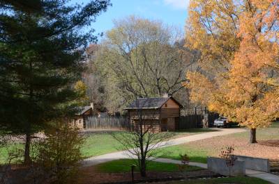
Fort Watauga replica in Sycamore Shoals Historic State Park.
The treaty was signed at a place called Sycamore Shoals on the Watauga River, and when I passed Sycamore Shoals Historic State Park, I decided to take a break here. I visited the visistor center and bought a few books about the Cherokees, and also Davy Crockett's autobiography (written with a little help). Then I visited the replica of the old Fort Watauga before I went to the river and walked to the actual shoals. I spent around 60 minutes here, before returning to my car. At that time the temperature (in the sun) had gone up to 97, which in Denmark would be impossible in November where the average is around 40.
From Elizabethton I continued on 321 northeast towards Trade. I drove a part of the way along Watauga Lake, a very beautiful lake, but where I could see the lake, I couldn't stop, and where I could stop, I couldn't see the lake, so I didn't get any pictures. Somewhere around the middle of the lake, I changed to Tennessee Road 67 which led me across the lake and further northeast to Mountain City. It was when I got here, I remembered why Jonesborough was interesting. In 1903 a young woman, Lillie Shaw, disappeared from her home a few miles outside Mountain City. Her husband had left her, and had moved to Ohio with their children. Apparently she had an affair with a married man, while she was living with a couple of neighbors she knew well. She was never seen again after her disappearence, but some time later what could be the remains of a burned human body, was found 1.5 mile away. The man of the couple she lived with was arrested for murder, made a partial confession and was found guilty in a trial. The trial took place in Jonesborough and the man, Finley Preston was sentenced to death. He was hanged on November 7th 1905. This was the last public execution ever in Tennessee and the last hanging. Soon after the electric chair replaced the gallows as means of execution. Besides that, Jonesborough has it's own ghost, and a famous one at that. The ghost in question is said to be the seventh president of the United States, Andrew Jackson. He spent some months in town in 1788, in the home of a Major Christopher Taylor. This house still exists, and even if it has been moved to a park in the historical part of town, Jackson can be seen entering the house via the front door. Some has even seen the president walking down the street in direction of the old courthouse. So that was yet another ghost I missed. I have written an article about the Mountain City murder on the Historic Stories Page.
Wine and dine
Just before Mountain City, I had passed Pandora. Here I made a stop at Doe Creek, where Tom Dooley was arrested by two deputy sheriffs from Wilkes County, North Carolina, Jack Adkins and Ben Ferguson, assisted by Colonel James Grayson from Trade. I took some pictures of the creek before I continued to Mountain City. From Mountain City I continued towards Trade, and suddenly I was in North Carolina. As the sun was still shining, I had decided to give Brown Mountain one more chance, but as soon as I crossed the state line the sun disappeared behind clouds, and it became foggy once more. Temperature was now down from the nice 85 to a still warm but more ordinary 72. So I gave up on Brown Moutain, at least for that day, and headed for Boone. From there I took US 421 around 50 miles east to exit 267 where I had left 421 many times before. Only a few hundred yards from the exit on Old Highway 421, you find Laurel Gray Vineyards and Winery, and that was my goal. My son had asked me me to buy some of their BBQ sauce, that he likes very much. I had a tasting, and bought a couple of bottles of white wine, and three bottles of sauce. The wine and one the bottles of sauce was for myself.
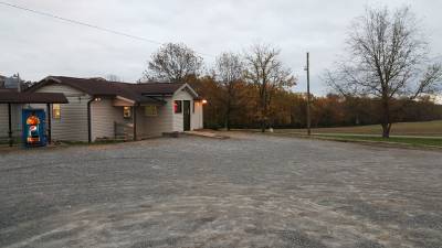
Korner Kitchen outside Union Grove.
Not far from Laurel Gray, outside Union Grove is a small diner, The Korner Kitchen. In 2004 Dorte and I met some very nice people here. At that time the place was called Gaby's Diner and when we got there, the place was completely full. You can read more about this in the article Meeting the Natives on the 2004 travel page. In 2012 Tim and I passed the place, but as we were not hungry at the time, we didn't visit. When we were ready to eat, we thought it would be to far to drive 70 miles only to eat. In 2013 I wanted to eat there, but the place was closed due to change of ownership. The place is in the middle of North Carolina's Amish-area, but I have never seen a single Amish, even if signs warn against horse carriages on the road. Neither did I this time. When we got to the place in 2004 the parking lot was full of pick-up trucks, and there were no tables available. I didn't have that problem this time. The parking lot was empty, and when I entered the place I was the only one there. While I was there one person come to buy some take-away, and one person ate there. The three young girls who was cooking and serving looked as if they would rather be anywhere else but there. The menu were almost the same as 11 years earlier, and so was the prices. In 2004 we had flounder for $ 6.95 and now it was $ 7.95. I had a burger though, and with something to drink and a good tip it cost me $ 10. One of the girls told me, that not many people in the area could afford eating out anymore, because of the economical crisis. When I get to the area in 2016, I will go back, it not for anything else, then to see if the place is still open.
From Union Grove I returned to Lenoir and Irish Rose. I had a cup of coffee with Rose, and chattec with her until some new guests arrived around 8 pm. Then I chatted with them for awhile before retiring to my own room.
The short stages on freeways added a few trucks to my list, so after today it looked like this:
| Swift Transportation | 13 |
| J. B. Hunt Transport Services | 13 |
| Knight Transportation | 7 |
| Werner Enterprises | 6 |
| C. R. England Inc. | 4 |
| Schneider National | 3 |
-
Return
to Tour de Macabre -
-
Return to Travel Stories -