Finding a place that does not exist
As mentioned in my last article, I had
planned to visit Mount Mitchell on my way north to Wilkesboro, but since I had
already been there the day before, there would be no need to repeat the visit.
True enough the view from the top the privous day was nothing to boast of, but
the weather certainly had not improved. Wilkesboro was to be the last town in
which I would stay, and here I had booked three nights, so it would give me two
full days in addition to the day I arrived. And as Mount Mitchell was out, I had
to think of something else to do, and I decided to go for a visit to Statesville
as my first goal of the day.
I left Cherokee the same way that I had arrived in town, taking U.S. Highway 19
through Maggie Valley and Lake Junaluska. That was the third time on that route
in three days. The weather was as already mentioned, not too good. Fog so thick
that I could barely see my own hood all the way through the mountains and the
first stretch of I -40. But after a while the fog lifted, however only to be
replaced by heavy rain, which continued on and off for the remainder of the day,
interspersed with a few breaks of dry weather, but the sun never shone through
the clouds. Statesville is located where I-40 and I-77 intersect, and the town
is the county seat of Iredell County and the place where Tom Dooley was hanged,
and that was the reason for my visit to the town.
 I
had been there before, both with Tim (in 2012) and with Dorte (2004) , and now I
wanted to see if I could find the place where Tom's executions had taken place.
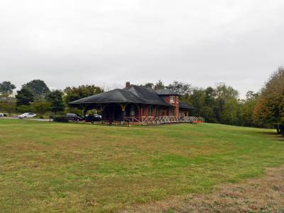
In 2004, we visited the old railway stationfrom 1906, which at the time was the
town's Visitor Information Center, and they told us that the execution had taken
place on the other side of the tracks, and we had just accepted that without
investigating further, not least because we was on our way north. The problem
was that there were several tracks going in multiple directions so it was
really not very informative, since they had not mentioned which of the tracks
that were involved. In 2012 the Information Center had moved away, although the
building was still there, and based on information from 2004, I tried to
identify the place that I thought would be the right place from calculations
made a year or so before our visit using Google Maps and Google Earth. The
result of these calculations was, that the place of execution was around the
southern end of what is now called South Center Street, and I took a few
pictures of this place. Since then however, I learned more through my research
on the matter. The execution took place in a field near the railway station,
which had existed before 1906, and it had been located about 300 meters
northeast of the 1906 depot building, not due north of this , as I thought
before. This place can not be precisely identified, but with some degree of
accuracy. In the immediate vicinity of where the old depot was in 1868, there
are two options for where the execution may have taken place , both located "on
the other side of the tracks " from the station from 1906. Which is the right
one depends on which side of the then tracks the field was, and it is difficult
if not impossible to determine. The place was called "The Circus Lot", but
apparently no one today nows exactly where it was. The best identification I had
found was a newspaper article from the 1950s , which described the place as "where
there is now a furniture factory." However, the furniture factory decommissioned
long ago, and it is not certain that the article was right.
I
had been there before, both with Tim (in 2012) and with Dorte (2004) , and now I
wanted to see if I could find the place where Tom's executions had taken place.
In 2004, we visited the old railway stationfrom 1906, which at the time was the
town's Visitor Information Center, and they told us that the execution had taken
place on the other side of the tracks, and we had just accepted that without
investigating further, not least because we was on our way north. The problem
was that there were several tracks going in multiple directions so it was
really not very informative, since they had not mentioned which of the tracks
that were involved. In 2012 the Information Center had moved away, although the
building was still there, and based on information from 2004, I tried to
identify the place that I thought would be the right place from calculations
made a year or so before our visit using Google Maps and Google Earth. The
result of these calculations was, that the place of execution was around the
southern end of what is now called South Center Street, and I took a few
pictures of this place. Since then however, I learned more through my research
on the matter. The execution took place in a field near the railway station,
which had existed before 1906, and it had been located about 300 meters
northeast of the 1906 depot building, not due north of this , as I thought
before. This place can not be precisely identified, but with some degree of
accuracy. In the immediate vicinity of where the old depot was in 1868, there
are two options for where the execution may have taken place , both located "on
the other side of the tracks " from the station from 1906. Which is the right
one depends on which side of the then tracks the field was, and it is difficult
if not impossible to determine. The place was called "The Circus Lot", but
apparently no one today nows exactly where it was. The best identification I had
found was a newspaper article from the 1950s , which described the place as "where
there is now a furniture factory." However, the furniture factory decommissioned
long ago, and it is not certain that the article was right.
Well, now I was back and would look into it
so I could take a few pictures for the Tom Dooley articles on this page and
elsewhere. The first place on the south side of the present tracks was pretty
easy to find, even if I were out on a small detour to get there, and I took some
pictures of the possible location of the gallows during a break in the rain. The
other place north of the tracks was easy to see from the old station, but
because of train traffic, I was reluctant to cross the tracks on foot, and I
could also see that there was a road close by, however, I did not know the name
of this road so I could not key it into the navigation unit. I drove around a
bit, but without significant results until it dawned on me that I had to go down
a very narrow one-way street, through an apparently quite poor neighborhood, but
finally I got to where I wanted and again I waited for a break in the rain, so I
could take a few pictures.
To drive from from Cherokee to Statesville will normally take 3 hours and 15
minutes or so, but the fog and the rain had prolonged that quite a bit. I didn't
leave Cherokee too early, and now I had been driving around in Statesville for
just over an hour, to get my pictures. This meant that the time was approaching
2 PM when I left town again. I
 headed north on small North Carolina Road 115,
which runs from Statesville to Wilkesboro, and may have been the same route that
Tom had been taken - just in the opposite direction - when he was transferred
from the prison in Wilkesboro to the prison in Statesville before his trial. I
was a little hungry, so decided to have lunch at The Korner Kitchen outside
Union Grove, where Dorte and I had dinner in 2004, and where Tim and I did not
eat in 2012. It was a small detou , but it didn't matter - at least not at first,
but when I found the place, it was closed due to the change of ownership , and a
sign informed that they would soon open again! Unfortunately I hadn't time to
wait for that.
I decided to ignore my hunger and instead continue north and visit Laurel Gray
Winery, where I had last been in 2012. Back then both Tim and I (in addition to
wine for me) bouught an excellent barbecue sauce , and now Tim had ordered more.
This time, as in 2004 it was the owner, Kim Myers herself who served me, but for
some reason she could not remember that we had seen each other nine years
earlier. Strange :-) Well, the wine was as good as usual, and I bought a few
bottles, and also barbecue sauce for both Tim and myself. When I my visit to
Laurel Gray was done I took the nearest road to Wilkesboro and my hotel, and I
arrived around 4.30 PM and got my room.
After relaxing at the hotel with a book for a couple of hours, I visited a
WallMart and boutght an extra bag for the trip home, as I now had both wine,
barbecue sauce and some previously purchased shirts etc to find room for. I
ended the day with dinner at the same Ruby Tuesday where I had had lunch at,
when I drove from Front Royal to Banner Elk. Originallly I had planned for an
evening visit to Brown Mountain , but the rain made me drop this venture and
hope for better weather the next day.
- Return to Alone in Fall -
- Return to Travel page -